The old slate mines - exploring Snowdonia's history
A leisurely walk (woodland) in national park Snowdonia starting and finishing in Clwyd, Wales, about 7.70km (4.78 mi) long with an estimated walking time of about 3:00h. It is unsuitable for families with children, prams & pushchairs, wheelchairs.
Elevation Profile
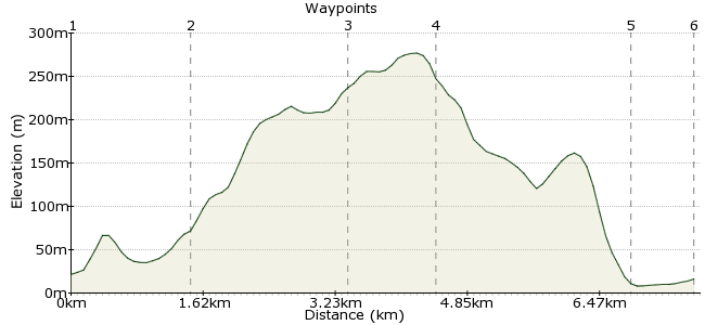
Ascent
246m (807ft)
Descent
251m (823ft)
Max. Elevation
280m (918ft)
Altitude Gain & Loss
497m (1630ft)
Start
Betws-y-Coed
End
Llanrwst
Distance
7.70km
(4.78mi)
(4.78mi)
Duration
~3:00h
Difficulty
Leisurely
Ordnance Survey Map
This walk offers an insight into Snowdonia's industrial past, before the outdoor enthusiasts arrived en masse. Heading out from Betws-y-Coed, the route takes you past several disused slate mines and through the Gwydyr Forest. The walk finishes by passing Gwydyr Uchaf, a 17th Century chapel, and Gwydir Castle, both just outside Llanrwst.
Walk Functions
Share
Nearby Walks
Along the Afon Llugwy
A leisurely, linear walk (riverside) starting in Clwyd, Wales, about 8.10km (5.03 mi) long, duration: ~3:00h.Llugwy and Gwydyr Forest
A moderate, circular walk (countryside) starting in Clwyd, Wales, about 10.80km (6.71 mi) long, duration: ~3:45h.Capel Garmon burial chamber
A moderate, circular walk (countryside) starting in Gwynedd, Wales, about 11.30km (7.02 mi) long, duration: ~4:00h.Walk Map
- $walk->POI array(0)
Waypoints
OS Grid SH795564
Start of the walk. Head from the station to the bridge across the Afon Llugwy and into the Forest Park.
OS Grid SH781569
Follow the path along the river to the Miners Bridge, where the workers used to cross on their way to the mines on the hillside. Carry on past the house at Diosgydd Uchaf.
About 1.45 km (~0.9 miles) from 
OS Grid SH773586
The route heads deeper into the forest, towards the house at Hafotypencraig. All around you can see the old shafts and tips from the Cyffty slate mine that once thrived here.
About 1.88 km (~1.17 miles) from 
OS Grid SH778594
How's your navigation? You can either follow the road through the forest, or make your way along one of the many forest tracks. More disused shafts and slate tips all along the way.
About 1.03 km (~0.64 miles) from 
OS Grid SH796610
The path continues to Gwydir Castle, built in 1490 after the War of the Roses. You can also stay for Bed and Breakfast here (although it is supposed to be haunted...)
www.gwydircastle.co.uk. The nearby Gwydyr Uchaf, a stone chapel built in 1673, is also worth visiting for its painted ceiling.
About 2.40 km (~1.49 miles) from 
 Llanrwst station
OS Grid SH801616
From the castle, it's a short walk to the small market town of Llanrwst, across the Afon Conwy.
About 0.78 km (~0.48 miles) from 

1 comment... join the discussion!
GaryShipp
This is a great walk when the weather is being typically Welsh. It stays off the tops and offers some shelter but with impressive views and a good deal of Industrial Archeology interest.