Cader Idris from Dolgellau
A moderate walk (mountain (above 600m)) in national park Snowdonia in Gwynedd, Wales, about 15.30km (9.51 mi) long with an estimated walking time of about 7:00h. It is unsuitable for families with children, prams & pushchairs, wheelchairs.
Elevation Profile
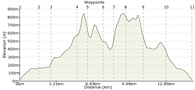
Ascent
857m (2811ft)
Descent
856m (2808ft)
Max. Elevation
850m (2788ft)
Altitude Gain & Loss
1713m (5619ft)
Start & End
Dolgellau
Distance
15.30km
(9.51mi)
(9.51mi)
Duration
~7:00h
Difficulty
Moderate
Cader Idris is one of the best walks in Wales. Its rocky ridges and steep cliffs stand out amongst the more gentle hills in this part of Wales. Most walkers use the path up from Minffordd, but this route takes the quieter approach from Dolgellau. It can be done in a long day from here, but the best way to enjoy this mountain is over two days, camping at Ty-nant or, even better, Llyn y Gadair. This puts you right in place for an early ascent and, with any luck, you'll have the summit to yourself!
Walk Functions
Share
Nearby Walks
Mawddach Trail
A moderate, linear walk (riverside) starting in Gwynedd, Wales, about 12.40km (7.71 mi) long, duration: ~3:30h.The Mawddach Trail from Dolgellau
A strenuous, circular walk (low hills and fells (below 600m)) starting in Gwynedd, Wales, about 21.70km (13.48 mi) long, duration: ~7:15h.Y Garn from Llanelltyd
A moderate, linear walk (mountain (above 600m)) starting in Gwynedd, Wales, about 10.70km (6.65 mi) long, duration: ~4:45h.Walk Map
- $walk->POI array(0)
Waypoints
OS Grid SH728177
The walk starts in Dolgellau. There are no trains, but several bus routes stop here. Head south out of town and pick up the bridleway towards Nant y Ceunant.
OS Grid SH716164
Across the road, the bridleway becomes a footpath and heads southwest. Keep going until you hit another minor road.
About 1.77 km (~1.1 miles) from 
OS Grid SH706160
If you are taking two days, it's decision time: either follow the road for 1km to the campsite at Ty Nant, or continue south on the footpath towards Llyn Gafr and Llyn y Gadair.
About 0.97 km (~0.6 miles) from 
OS Grid SH701138
Is there a better wild camp in Britain? This corrie, overlooked by the Cyfrwry arete and Penygadair, the summit of Cader Idris, is as dramatic a place to camp as you can find. Follow the base of the mountain to the western end to pick up the Pony Path.
About 2.29 km (~1.42 miles) from 
OS Grid SH696131
Head up the Pony Path to the summit.
About 0.87 km (~0.54 miles) from 
OS Grid SH709130
Reach the summit of the mountain, also known as Penygadair.
About 1.39 km (~0.86 miles) from 
OS Grid SH718134
Great views over Llyn Cau as you follow the summit ridge east.
About 0.96 km (~0.6 miles) from 
OS Grid SH727136
At 863m, this is the second highest summit on Cader Idris. Enjoy the views back into the horseshoe and across Llyn Cau before following the ridge west back to Penygadair.
About 0.91 km (~0.57 miles) from 
OS Grid SH742140
Take care as you descend via Gau Graig.
About 1.56 km (~0.97 miles) from 
OS Grid SH743158
Head for Bwlch 'coch and then follow the track back to Dolgellau.
About 1.83 km (~1.14 miles) from 
 Dolgellau
OS Grid SH727176
Relax and recuperate in Dolgellau. There's a selection of quiet, friendly pubs in the town - check out the Cross Keys Inn on Mill Street.
About 2.40 km (~1.49 miles) from 
