Cir Mhor from Mid Sannox
A moderate walk (mountain (above 600m)) in Ayrshire, Scotland, about 12.10km (7.52 mi) long with an estimated walking time of about 5:45h. It is unsuitable for families with children, prams & pushchairs, wheelchairs.
Elevation Profile
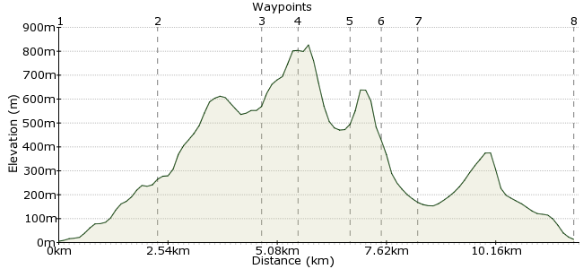
Ascent
777m (2549ft)
Descent
769m (2522ft)
Max. Elevation
830m (2723ft)
Altitude Gain & Loss
1546m (5071ft)
Start & End
Mid Sannox
Distance
12.10km
(7.52mi)
(7.52mi)
Duration
~5:45h
Difficulty
Moderate
Ordnance Survey Map
The Isle of Arran has several excellent walks, especially in the rugged peaks and ridges in the mountainous centre of the island. Cir Mhor is one of the most rewarding routes. Note that part of this route - the Witch's Step - is a challenging scramble. The walk can be reached from the little cluster of hamlets known collectively as Sannox.
Arran is well served by buses, which travel all around the island. Most services start from the port of Brodick, the main entry point to the island.
Walk Functions
Share
Nearby Walks
Goatfell and Coire na Ciche on the Isle of Arran
A moderate, linear walk (mountain (above 600m)) starting in Ayrshire, Scotland, about 10.00km (6.21 mi) long, duration: ~5:15h.The Cock of Arran
A moderate, circular walk (coast) starting in Ayrshire, Scotland, about 10.10km (6.28 mi) long, duration: ~3:00h.Goat Fell
A moderate, circular walk (mountain (above 600m)) starting in Ayrshire, Scotland, about 14.00km (8.70 mi) long, duration: ~6:30h.Walk Map
- $walk->POI array(0)
Waypoints
OS Grid NS016453
The walks starts in the small hamlet of Mid Sannox, on the bus route around the north of Arran. Take the track opposite the car park and cross the river at the footbridge.
OS Grid NR993461
Follow the walls next to the footbridge and head uphill to Cnocan Donna. Look for the path heading onto the ridge, towards Suidhe Fhearghas.
About 2.40 km (~1.49 miles) from 
OS Grid NR976444
From Suidhe Fhearghas, follow the ridge to Ceum na Caillich - also known as the Witch's Step. This is a very tricky bit of scrambling, especially heading down. An easier path round can be found just to the north of the main drop.
About 2.40 km (~1.49 miles) from 
OS Grid NR968443
The path follows the ridge to Caisteal Abhail, the highest point of the walk at 847m.
About 0.80 km (~0.5 miles) from 
OS Grid NR973432
The ridge continues past Portcullis Buttress and onto the summit of Cir Mhor. From here there are great views along the ridges to Goatfell and Beinn Tarsuinn - Scotland in minature, like they say on the tourist brochures!
About 1.30 km (~0.81 miles) from 
OS Grid NR979430
From Cir Mhor summit, take the path heading southeast towards Goatfell. After about 600m, there is a path dropping down into the Glen Sannox valley.
About 0.61 km (~0.38 miles) from 
OS Grid NR984436
The path meets the Sannox Burn, and takes you back to Mid Sannox.
About 0.71 km (~0.44 miles) from 
 Back to Mid Sannox
OS Grid NS016452
From here you can pick up the bus to wherever you are staying - there is also accomodation dotted around Sannox. If you have some time, there is a good pub in the Sannox Bay Hotel.
About 3.64 km (~2.26 miles) from 
