The Cock of Arran
A moderate walk (coast) in Ayrshire, Scotland, about 10.10km (6.28 mi) long with an estimated walking time of about 3:00h. It is unsuitable for families with children, prams & pushchairs, wheelchairs.
Elevation Profile
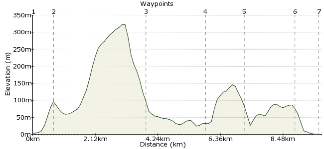
Ascent
81m (265ft)
Descent
83m (272ft)
Max. Elevation
330m (1082ft)
Altitude Gain & Loss
164m (537ft)
Start & End
Lochranza
Distance
10.10km
(6.28mi)
(6.28mi)
Duration
~3:00h
Difficulty
Moderate
Ordnance Survey Map
The Isle of Arran is ideal for car-free walking. Good bus services operate all around the island, providing easy access to many fine routes in the walker's paradise.
This route starts in the pretty village of Lochranza, where you can see otters in the bay and red deer on the hills, plus many birds of prey. The walk heads over the hill of Torr Meadhonach to the rocky northern tip of Arran.
Walk Functions
Share
Nearby Walks
Cir Mhor from Mid Sannox
A moderate, circular walk (mountain (above 600m)) starting in Ayrshire, Scotland, about 12.10km (7.52 mi) long, duration: ~5:45h.Goatfell and Coire na Ciche on the Isle of Arran
A moderate, linear walk (mountain (above 600m)) starting in Ayrshire, Scotland, about 10.00km (6.21 mi) long, duration: ~5:15h.Goat Fell
A moderate, circular walk (mountain (above 600m)) starting in Ayrshire, Scotland, about 14.00km (8.70 mi) long, duration: ~6:30h.Walk Map
- $walk->POI array(0)
Waypoints
OS Grid NR938502
Start at the Field Studies Centre in Lochranza. Cross the river via the road and take the path towards Narathan.
OS Grid NR946502
Take the left-fork where the path splits and head uphill. The path crosses the Allt Eadaraidh and heads around the side of Torr Meadhonach.
About 0.80 km (~0.5 miles) from 
OS Grid NR977506
The path drops down on the northern side of Creag Ghlas Laggan, with fantastic views out to sea across the Sound of Bute.
About 3.13 km (~1.94 miles) from 
OS Grid NR959518
The path follows the rocky coastline to the Cock of Arran. Look out for Ossian's Cave, a small sea cave on the shore.
About 2.08 km (~1.29 miles) from 
OS Grid NR947523
Geologists know Arran as one of the places where James Hutton, in the 1700s, found evidence to propose his theory that the earth's surface had evolved over time. Here you can see the different rock strata lying in different directions(there's more details at the site).
About 1.30 km (~0.81 miles) from 
OS Grid NR931514
Heading further around the coastline, look for otters fishing from the rocks in Loch Ranza, and seals in the bay.
About 1.77 km (~1.1 miles) from 
 Lochranza Castle
OS Grid NR933506
The path follows the coast back into Lochranza, where you can explore the ruins of the old castle. There is a youth hostel if you are planning to stay overnight. The Lochranza Hotel has a good bar, with over 100 whiskies - enough to keep you busy in the evening!
About 0.82 km (~0.51 miles) from 
