Ingleborough from Ribblehead
A moderate walk (mountain (above 600m)) in national park Yorkshire Dales starting and finishing in North Yorkshire, England, about 15.00km (9.32 mi) long with an estimated walking time of about 5:30h. It is unsuitable for families with children, prams & pushchairs, wheelchairs.
Elevation Profile
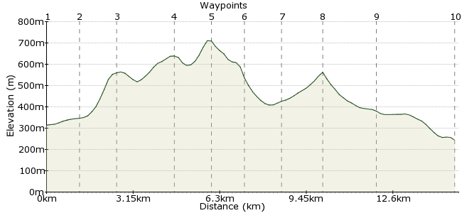
Ascent
402m (1318ft)
Descent
472m (1548ft)
Max. Elevation
720m (2362ft)
Altitude Gain & Loss
874m (2866ft)
Start
Ribblehead station
End
Lancaster
Distance
15.00km
(9.32mi)
(9.32mi)
Duration
~5:30h
Difficulty
Moderate
Ordnance Survey Map
A popular challenge for walkers in the Yorkshire Dales is to tackle the three highest peaks - Whernside, Pen-y-ghent and Ingleborough - in one day. That's all well and good, but it fails to give each distinct hill the attention it deserves.
Ingleborough is a fine walk on its own and the best way to enjoy the peak is to walk right over it. Starting at Ribblehead station, tucked in between the three peaks, this walk goes over the summit before dropping down to Horton in Ribblesdale station.
Walk Functions
Share
Nearby Walks
The 3 Peaks
A hard, circular walk (mountain (above 600m)) starting in Lancashire, England, about 33.20km (20.63 mi) long, duration: ~13:30h.A long Whernside circular from Ribblehead
A strenuous, circular walk (mountain (above 600m)) starting in Lancashire, England, about 24.40km (15.16 mi) long, duration: ~8:15h.Ribblehead-Chapel-le-Dale-Ribblehead
A moderate, circular walk (countryside) starting in Lancashire, England, about 10.90km (6.77 mi) long, duration: ~3:15h.Walk Map
- $walk->POI array(0)
Waypoints
OS Grid SD765789
Is there a better station from which to start a car-free walk than Ribblehead? Take the path from the station to Gauber Road and turn right. After about 600m, take the footpath heading back under the railway line. You can also reach Ribblehead by Dalesbus: www.dalesbus.org
OS Grid SD772778
Pass through the rocky ground and onto the northern end of Ingleborough. Follow the path running next to the wall.
About 1.29 km (~0.8 miles) from 
OS Grid SD763770
The first mini summit of the day is Park Fell. Keep heading along the ridge.
About 1.21 km (~0.75 miles) from 
OS Grid SD754752
This is the second of the three summits on Ingleborough, reaching 650m. There are good views on the eastern side into Ribblesdale. Carry on along the ridge to Ingleborough.
About 2.10 km (~1.3 miles) from 
OS Grid SD742746
The summit! And the second highest point in the Yorkshire Dales. From the top, there is a direct route into Ribblesdale, but instead head south towards Little Ingleborough.
About 1.32 km (~0.82 miles) from 
OS Grid SD743734
The path drops off this spur and splits into two. Take the path heading southeast.
About 1.14 km (~0.71 miles) from 
OS Grid SD752725
This detour takes you to the entrance of Gaping Gill - a massive underground cavern 105m deep. From the surface, you can peer into the crater and hear the Fell Beck crashing to the floor below.
About 1.22 km (~0.76 miles) from 
OS Grid SD766719
Drop down to Long Scar and continue along the bridleway via Crummock Dale.
About 1.52 km (~0.94 miles) from 
OS Grid SD777734
The path heads through the rocky ground of Sulber Nick towards Horton in Ribblesdale. There are lots of shake holes around here, marking the entrance to more underground caves.
About 1.86 km (~1.16 miles) from 
 Horton in Ribblesdale
OS Grid SD804725
The walk finishes in pretty Horton in Ribblesdale, on the same trainline as Ribblehead. If you have time before your train home, head for the Crown Hotel, which is popular with walkers.
About 2.84 km (~1.76 miles) from 

1 comment... join the discussion!
mac.hawk
In my opinion the best way to approach or descend Ingleborough is via Park/Simon Fell either along the 'lip' or the summits. This route is as good as any. Once reaching Horton visit The Crown (lounge) and despair at the times of the previous winners of the 3 Peaks Race!! If you travel from West Yorkshire and use the Settle to Carlisle line a lot, join the Friends of the S C & buy a Gold Card. Get's you 33% of all tickets and fabulous discounts in the winter (e.g. Nov 2010 to Feb 2011 £6 day return to anywhere on the line)