Ben Cruachan
A moderate walk (mountain (above 600m)) in Argyll and Bute, Scotland, about 10.60km (6.59 mi) long with an estimated walking time of about 6:00h. It is unsuitable for families with children, prams & pushchairs, wheelchairs.
Elevation Profile
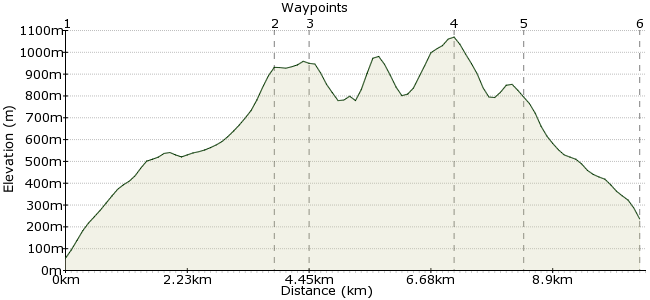
Ascent
1010m (3313ft)
Descent
830m (2723ft)
Max. Elevation
1070m (3510ft)
Altitude Gain & Loss
1840m (6036ft)
Start & End
Falls of Cruachan station
Distance
10.60km
(6.59mi)
(6.59mi)
Duration
~6:00h
Difficulty
Moderate
Ordnance Survey Maps
The Cruachan Horseshoe is so good it gets its own station - the Falls of Cruachan, a request stop on the line between Oban and Crianlarich. A circuit of the horseshoe, which includes two Munroes, is a fine day out, with much of the route along a high-level ridge. This connects the six peaks that surround the Cruachan Reservoir, which was built to provide water for the power station. The high point is Ben Cruachan, reaching an impressive 1126m.
Walk Functions
Share
Nearby Walks
Beinn Eunaich and Beinn a' Chochuill
A moderate, circular walk (mountain (above 600m)) starting in Argyll and Bute, Scotland, about 15.00km (9.32 mi) long, duration: ~7:30h.Ben Oss and Beinn Dubhchraig
A moderate, circular walk (mountain (above 600m)) starting in Argyll and Bute, Scotland, about 18.10km (11.25 mi) long, duration: ~8:15h.Ben Lui from Tyndrum
A moderate, circular walk (mountain (above 600m)) starting in Stirlingshire, Scotland, about 15.70km (9.76 mi) long, duration: ~7:00h.Walk Map
- $walk->POI array(0)
Waypoints
OS Grid NN079268
After alighting at the station (remember it's a request stop!), take the footpath on the left hand side of Allt Cruachan, which leads up to the dam and reservoir. Head for the eastern side of the reservoir, where there is a clear path.
OS Grid NN095302
It's possible to take in the summit of Beinn a' Bhuiridh, but most people head straight for Lairig Torran and the summit of Stob Garbh, where the ridge starts in earnest.
About 3.84 km (~2.39 miles) from 
OS Grid NN095309
From Stob Garbh, a few wonderful hours of ridge walking lie in wait! It's a short walk to Stob Diamh, the first Munro of the day at 998m.
About 0.60 km (~0.37 miles) from 
OS Grid NN069304
The ridge from Stob Diamh to Ben Cruachan, via Drochaid Ghlas, is one of the finest ridge walks in Scotland (and that's up against some pretty tough competition). Enjoy the views and keep the eyes peeled for golden eagles!
About 2.64 km (~1.64 miles) from 
OS Grid NN071292
Follow the ridge round to Meall Cuanail. On a clear day, several of the islands along Scotland's West Coast are visible. Well worth the climb for views like these!
About 1.20 km (~0.75 miles) from 
 Falls of Cruachan
OS Grid NN079272
The path from Meall Cuanail drops to the dam, from where you can retrace your steps past the falls and back to the station for the train home.
About 2.15 km (~1.34 miles) from 
