Beinn a' Bhuird
A strenuous walk (mountain (above 600m)) in national park Cairngorms in Aberdeenshire, Scotland, about 28.10km (17.46 mi) long with an estimated walking time of about 10:45h (1 overnight stay). It is unsuitable for families with children, prams & pushchairs, wheelchairs.
Elevation Profile
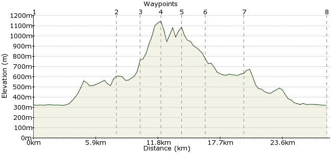
Ascent
824m (2703ft)
Descent
830m (2723ft)
Max. Elevation
1150m (3772ft)
Altitude Gain & Loss
1654m (5426ft)
Start & End
Invercauld Bridge, near Braemar
Distance
28.10km
(17.46mi)
(17.46mi)
Duration
~10:45h
Difficulty
Strenuous
For most walkers, Braemar is synonymous as the entry to the heart of the Cairngorms. Plenty of long distance, multi-day car-free walking options start here, heading deep into the many lonely glens of the National Park, before emerging a day or two later, tired, smelly and happy.
One of the nearest Munros to Braemar, Beinn a' Bhuird provides a great taste of the region. It's possible to complete it in one long day, but also enjoyable over two days, camping out on the hills.
Walk Functions
Share
Nearby Walks
Morrone from Braemar
A moderate, circular walk (mountain (above 600m)) starting in Aberdeenshire, Scotland, about 13.20km (8.20 mi) long, duration: ~5:30h.Ben Macdui from the north
A moderate, circular walk (mountain (above 600m)) starting in Highlands, Scotland, about 15.60km (9.69 mi) long, duration: ~6:30h.Braeriach
A strenuous, circular walk (mountain (above 600m)) starting in Highlands, Scotland, about 20.00km (12.43 mi) long, duration: ~8:30h.Walk Map
- $walk->POI array(0)
Waypoints
OS Grid NO187911
The walk in to Beinn a' Bhuird starts at Invercauld Bridge, between Braemar and Crathie. Ask the driver to drop you off, and take the path heading up to Invercauld House.
OS Grid NO119954
The long walk in is a common feature of walking in the Cairngorms. The track that follows the Allt an t-Slugain passes Altdourie, through a patch of coniferous woodland, and then climbs slowly along the glen to Slugain Lodge.
About 8.02 km (~4.98 miles) from 
OS Grid NO104969
Just past Slugain Lodge, the path splits in different directions. Take the left-hand fork towards the ford on the Quioch Water. Across the burn (and hopefully with feet still dry), continue on the path leading up the southern face of Carn Fiaclach.
About 2.12 km (~1.32 miles) from 
OS Grid NO094984
The path continues past Carn Fiaclach on to South Top. Not one of the most inspiring or evocative Scottish mountain names, but a sense of achievement will prevail nonetheless with most of the day's climbing done.
About 1.83 km (~1.14 miles) from 
OS Grid NJ093004
Follow the edge of the plateau, which drops dramatically down a series of steep buttresses to Dubh Lochan. The summit of Beinn a' Bhuird is about 2.5km from South Top, and slightly higher at 1197m.
About 2.00 km (~1.24 miles) from 
OS Grid NO113992
Follow the edge of the plateau from the summit, and in the col between Beinn a' Bhuird and Cnap a' Cleirich, head downhill, using the Allt Dearg as a handrail if necessary. At the foot of the slope, pick up the path heading south alongside the burn.
About 2.29 km (~1.42 miles) from 
OS Grid NO118957
The path runs south beneath Creag an Dail Mhor and back to Slugain Lodge. There is a secret howff around here if you are staying out overnight, but it's bad practice to reveal the locations publicly - you'll have to ask the locals! Otherwise, there are plenty of good wild camp spots near here.
About 3.53 km (~2.19 miles) from 
 Back to Invercauld Bridge
 OS Grid NO185913
The long walk back to civilisation follows the same track you came in on, and will no doubt seem much, much longer. If you miss the last bus, Braemar is only 3 miles to the west along the road.
About 7.98 km (~4.96 miles) from 

1 comment... join the discussion!
GaryShipp
Unbelievable for Scotland I know! I put it down to the weather of late so every (grey) cloud does have a silver lining!