Exmoor's extraordinary coastline
A moderate walk (coast) in national park Exmoor starting and finishing in Devon, England, about 15.50km (9.63 mi) long with an estimated walking time of about 6:30h. It is unsuitable for families with children, prams & pushchairs, wheelchairs.
Elevation Profile
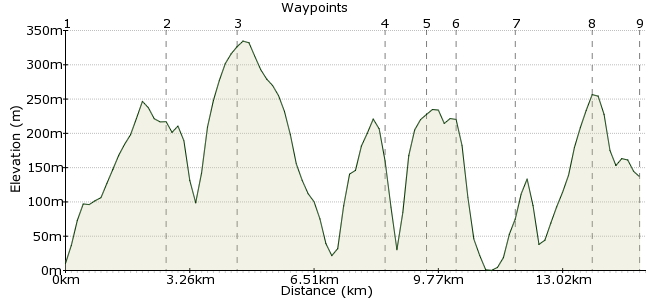
Ascent
702m (2303ft)
Descent
575m (1886ft)
Max. Elevation
340m (1115ft)
Altitude Gain & Loss
1277m (4189ft)
Start
Combe Martin
End
Lynton
Distance
15.50km
(9.63mi)
(9.63mi)
Duration
~6:30h
Difficulty
Moderate
Ordnance Survey Map
Devon is blessed with a diverse mix of breathtaking scenery, not least some of the finest coastline in Britain. The South West Coast Path explores much of this, and the section between Lynton and Combe Martin is particularly impressive. It's possible to do this walk in either direction, but there are more bus connections from Lynton if you are heading elsewhere, and a later bus back to Combe Martin each day. You could also try the Moor Rover service: www.atwest.org.uk/moorrover.htm
Walk Functions
Share
Nearby Walks
Braunton Burrows
A moderate, circular walk (coast) starting in Devon, England, about 16.20km (10.07 mi) long, duration: ~4:45h.Lynton & Lynmouth
A leisurely, circular walk (coast) starting in Devon, England, about 5.70km (3.54 mi) long, duration: ~2:15h.Exmoor's extraordinary coastline Part II
A moderate, linear walk (coast) starting in Devon, England, about 18.10km (11.25 mi) long, duration: ~7:15h.Walk Map
- $walk->POI array(0)
Waypoints
OS Grid SS577473
This is the perfect place to start any walk, and a good base for further coastal walking (i.e. in the other direction to Ilfracombe). The village spreads along one long street, and is the epitome of 'tourist friendly' with everything you could need.
OS Grid SS602483
The two hills of Little Hangman and Great Hangman make an interesting start to the walk. The cliff at Great Hangman is the highest in Britain at 244m.
About 2.69 km (~1.67 miles) from 
OS Grid SS619476
Continue along the SWCP (which doubles as the Tarka Trail here) to Holdstone Hill. You can leave the Coastal Path to the summit of the hill at 349m - a good place to get a coastal panorama east and west.
About 1.87 km (~1.16 miles) from 
OS Grid SS654495
The path continues along the coastline, high above a series of beaches and coves. It's worth walking down to the beach at Heddon's Mouth, a beautiful spot for a mid-morning sandwich.
About 3.97 km (~2.47 miles) from 
OS Grid SS664491
Cross via the footbridge and climb up the steep valley side to rejoin the SWCP, heading past Great Burland Rocks.
About 1.03 km (~0.64 miles) from 
OS Grid SS671491
The next stage heads through a lush deciduous woodland. The cliffs are still very steep here - keep those dogs (and children) on a tight lead!
About 0.71 km (~0.44 miles) from 
OS Grid SS686490
Another great viewpoint - Crock Point is a small headland overlooking rocky beaches below.
About 1.55 km (~0.96 miles) from 
OS Grid SS705493
Join the road for a short section, before entering the Valley of Rocks! This is probably the highlight of the day - a series of outcrops to scramble about on, with evocative names like Rugged Jack! A large family of feral goats also live here (you'll smell them before you see them).
About 1.93 km (~1.2 miles) from 
 Lynton
OS Grid SS719494
Finish up in Lynton - also a pleasant place to stay if you miss the last bus, or just want to go back to the rocks again tomorrow!
About 1.37 km (~0.85 miles) from 
