Haworth to Hebden Bridge
A moderate walk (moorland) starting and finishing in West Yorkshire, England, about 13.80km (8.57 mi) long with an estimated walking time of about 5:00h. It is unsuitable for families with children, prams & pushchairs, wheelchairs.
Elevation Profile
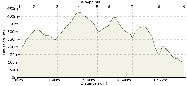
Ascent
328m (1076ft)
Descent
403m (1322ft)
Max. Elevation
430m (1410ft)
Altitude Gain & Loss
731m (2398ft)
Start
Haworth
End
Hebden Bridge
Distance
13.80km
(8.57mi)
(8.57mi)
Duration
~5:00h
Difficulty
Moderate
Ordnance Survey Map
The South Pennines are perfect car-free walking territory. The towns of Lancashire and Yorkshire crowd in on either side, providing plenty of access to the wild moors in between. This walk, between the pretty villages of Haworth and Hebden Bridge, takes you across some of the finest scenery in the region, including Crimsworth Dean Beck. There are regular trains and buses from either end, making getting there and away a piece of cake. Regular buses run between the two towns as well.
Walk Functions
Share
Nearby Walks
Rombalds Moor
A moderate, linear walk (low hills and fells (below 600m)) starting in Bradford, England, about 12.50km (7.77 mi) long, duration: ~4:15h.Hebden Bridge Birthday Walk
A moderate, circular walk (countryside) starting in West Yorkshire, England, about 12.40km (7.71 mi) long, duration: ~4:15h.Shipley Glen
A leisurely, circular walk (countryside) starting in West Yorkshire, England, about 5.90km (3.67 mi) long, duration: ~2:00h.Walk Map
- $walk->POI array(0)
Waypoints
OS Grid SE035372
Start from Haworth, a pleasant little tourist hotspot in West Yorkshire and famous for its connections with the Bronte sisters. Regular buses run here, and you can even arrive by steam train in the summer months!
OS Grid SE024366
Footpaths leave Haworth in all directions, so it can be a bit tricky to get the right path. Head for Penistone Hill, from where a marked path will take you to Hebden Bridge.
About 1.25 km (~0.78 miles) from 
OS Grid SE016350
The path winds through the farms around Haworth Moor and past Leeshaw Reservoir.
About 1.83 km (~1.14 miles) from 
OS Grid SE004336
The route heads along Bodkin Lane and over Stairs Hill. There aren't any though, so you will have to plod up the hill to Top of Stairs, the high point of the route.
About 1.82 km (~1.13 miles) from 
OS Grid SD994325
The walk drops into the northern end of Crimsworth Dean. Cross Paddock Beck at Grain Water Bridge and climb again up the western side of the valley.
About 1.45 km (~0.9 miles) from 
OS Grid SD988319
One route continues along Middle Dean into Hebden Bridge. But a better, slightly longer route, is to leave the path at Hardibut Clough and take the path beneath Shackleton Knoll.
About 0.89 km (~0.55 miles) from 
OS Grid SD974306
The last stretch of the walk is perhaps the most enjoyable - the woody riverside of Hebden Dale, which is owned by the National Trust. Follow Hebden Water past crags and cotton mills in this wonderful little valley.
About 1.93 km (~1.2 miles) from 
OS Grid SD988291
Cross the river where it meets Crimsworth Dean Beck at New Bridge. Follow the path through the woodland on the western side of the river into Hebden Bridge.
About 2.13 km (~1.32 miles) from 
 Hebden Bridge
OS Grid SD992270
The walk ends at the 'gateway to the Pennines', Hebden Bridge. Lots of places to eat, drink and rest here - it's a place where hippies headed in the 1960s, so organic lentil burgers aplenty. For options, visit www.hebdenbridge.co.uk/tourist-info
About 2.05 km (~1.27 miles) from 
