A coastal classic - Scarborough to Filey
A moderate walk (coast) starting and finishing in North Yorkshire, England, about 13.20km (8.20 mi) long with an estimated walking time of about 3:45h. It is unsuitable for families with children, prams & pushchairs, wheelchairs.
Elevation Profile
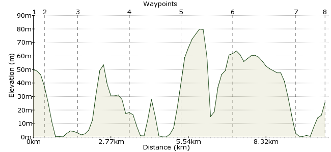
Ascent
30m (98ft)
Descent
54m (177ft)
Max. Elevation
80m (262ft)
Altitude Gain & Loss
84m (275ft)
Start
Scarborough
End
Filey
Distance
13.20km
(8.2mi)
(8.2mi)
Duration
~3:45h
Difficulty
Moderate
Being a collection of islands, Britain is spoilt when it comes to coastal scenery. But this section in the northeast of Yorkshire still takes some beating. There is some fantastic scenery, especially around Cayton Bay, a popular surfing spot. The walk is also part of the Cleveland Way National Trail. Regular buses run between the two towns, making it easy to undertake in either direction.
Walk Functions
Share
Nearby Walks
Filey & The Brigg
A leisurely, circular walk (coast) starting in North Yorkshire, England, about 6.70km (4.16 mi) long, duration: ~1:45h.Circular Walk Speeton to Hunmanby Gap
A leisurely, circular walk (coast) starting in North Yorkshire, England, about 8.90km (5.53 mi) long, duration: ~2:45h.Goathland to Grosmont
A leisurely, linear walk (countryside) starting in North Yorkshire, England, about 6.20km (3.85 mi) long, duration: ~1:45h.Walk Map
- $walk->POI array(0)
Waypoints
OS Grid TA039884
From the town centre, head towards the road - it's pretty well signposted. You can also visit the ruined castle before the walk if you like - it's on the small outcrop northeast of the town centre.
OS Grid TA044884
The first section is along the southern town beach, South Sands. Walk on the sand or the pavement heading south!
About 0.54 km (~0.34 miles) from 
OS Grid TA049871
You leave the town as you reach Black Rocks - still lots of seaview hotels though! Continue past White Nab and Cornelian Bay along the Cleveland Way.
About 1.35 km (~0.84 miles) from 
OS Grid TA064853
This vast sandy bay is the highlight of the walk in terms of scenery. Managed by the National Trust, it's makes a beautiful lunch stop!
About 2.36 km (~1.47 miles) from 
OS Grid TA083841
The walk continues past some spectacularly rocky coastal scenery - Castle Rocks and Yons Nab near Lebberston Cliff. Pick your way down the cliff to the shore for some good old-fashioned rock-pooling. Limpets count for 1 point, crabs 5.
About 2.22 km (~1.38 miles) from 
OS Grid TA101827
Carry on along past The Wyke, sticking to the Cleveland Way. It's a bit quieter along this section, so a chance to enjoy those sea views in a bit of peace and quiet.
About 2.28 km (~1.42 miles) from 
OS Grid TA125816
This promontory juts right out to the sea. It's beloved of many locals, who come here to birdwatch, dive, fish, climb and look for fossils. So whatever you fancy, it's worth making it this far! Be aware that the cliffs on the northern side are pretty precarious, and the tide cuts bits off at times.
About 2.71 km (~1.68 miles) from 
 Filey
FileyOS Grid TA118804
Finish the walk by continuing into the town of Filey, where there are pubs and cafes a-plenty, and regular buses back to Scarborough. It's also a popular holiday resort, with plenty of accommodation options.
About 1.33 km (~0.83 miles) from 

11 comments... join the discussion!
Sandra
Hi can I ask what makes this unsuitable for families with children and ‘or push chairs?
Timwoods
Hi Sam, You can check the gradients on the elevation profile, near the top of this page. There are quite a few ups and downs, but none that are overly high. And yes, most of the route runs along the clifftop path, with a bit of road walking at the start and finish. Tim
Samuel
Does this walk have a lot of gradients and is it mostly Cliff top pathway Thanks Sam
natterbags
what a brill idea especially as i can walk so far and bus back ,to bus to where i finished in my own time and spread it out over a few days or another visit which is a good excuse to return to Scarborough for a mini holiday
Raymond
Hello Please can you tell me if this route is suitable for cycling along - cheers, Ray
Timwoods
I can't think of any reason why not, although it would depend on the huskey of course.
Barnze
Is this a good walk for a huskey?
Timwoods
Hallo, we recommend people buy an OS map to take with them - ours are to show the route only, not really suitable for navigation. You can buy one with a discount from Aqua3 - click on the link showing a map at the top of the page.
Acatia
Thanks! I'm going to try it this week. Is there a link to a clearer map anywhere, I'm struggling to get a full page version of this one to take with me, just in case? Acatia
Timwoods
Hallo It's easy to do it the other way - just get a bus or train to Filey, and keep the sea on your right! Our walks tend to finish where there are more transport connections, to avoid leaving people stranded in the wilds, but in this case it's fine whichever way you head. Enjoy! Tim
Acatia
Hi, This might be a silly question but I'm quite new to walking and was just wondering how easy it is to reverse this walk? I have to get a bus back from Scarborough to Leeds so would ideally get to Filey and do the walk backwards. I get lost very easily so just wanted to check how well it is signposted/how easy the route is to follow! Thanks