Niton to St Lawrence to Whitwell
A leisurely walk (coast) in Isle of Wight, England, about 8.00km (4.97 mi) long with an estimated walking time of about 2:30h. It is unsuitable for families with children, prams & pushchairs, wheelchairs.
Elevation Profile
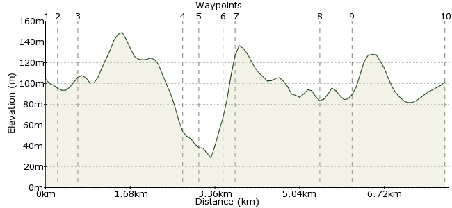
Ascent
98m (321ft)
Descent
110m (360ft)
Max. Elevation
150m (492ft)
Altitude Gain & Loss
208m (681ft)
Start & End
Niton High Street
Distance
8.00km
(4.97mi)
(4.97mi)
Duration
~2:30h
Difficulty
Leisurely
Ordnance Survey Map
This walk starts in the village of Niton (pronounced Nigh-ton), descends down the undercliff into St Lawrence with its warming microclimate, taking in two interesting churches, climbs back up the cliff, proceeds to the village of Whitwell, with a pub to eat in, then returns to Niton via a track through a field. It follows much of the Pilgrim Way, signposted, between the wells at St Lawrence and Whitwell. Bus No16 serves Ventnor, Shanklin and St Lawrence. No6 serves Niton, Ventnor and Newport.
Walk Functions
Share
Nearby Walks
St Catherine's Lighthouse, Niton
A leisurely, circular walk (coast) starting in Isle of Wight, England, about 3.50km (2.17 mi) long, duration: ~1:15h.Circular Tour Around the River Yar
A leisurely, circular walk (riverside) starting in Isle of Wight, England, about 5.80km (3.60 mi) long, duration: ~1:30h.Wilverley Common in the New Forest
A leisurely, linear walk (woodland) starting in Hampshire, England, about 8.90km (5.53 mi) long, duration: ~2:45h.Walk Map
- $walk->POI array(0)
Waypoints
OS Grid SZ505767
Start of the walk
OS Grid SZ507767
The bus drops you off around the corner from the pub. Take the path opposite the pub, signposted St Lawrence. The path meanders through backyards and gardens then crosses a bridleway.
About 0.21 km (~0.13 miles) from 
OS Grid SZ510764
Head SE up the hill through open fields. Go over the style and across another field until you reach the cliff. Head E along the coastal path for 1.5km.
About 0.34 km (~0.21 miles) from 
OS Grid SZ530762
Shortly after the radio tower (NB the OS map shows a crop of towers, but we could only see one) take the steep winding path S down the cliff. NB There is a bench at the top with stunning views - a good point to stop for a snack.
About 2.08 km (~1.29 miles) from 
OS Grid SZ532763
The cliff descent brings you out on a road. Continue S through the housing estate until you hit the main road.
About 0.22 km (~0.14 miles) from 
OS Grid SZ537765
The church is on the right-hand side as you head SW along the main road. It has impressive stained glass windows designed by Pre-Raphaelite artists. On leaving the church, turn back on yourself and follow the road W for 100 yards.
About 0.43 km (~0.27 miles) from 
OS Grid SZ535766
Take the marked path N to St Lawrence old church, fondly known as the smallest parish church in England. On leaving the church, bear W along the B road until you return to the path up the cliff. At the top, bear NNW along St Rhadegund's path, which is marked, across the fields
About 0.20 km (~0.12 miles) from 
OS Grid SZ522775
Take bridleway SW over the brook (don't cross over the sty). Just before the main road note the putative holy well on the left.
About 1.65 km (~1.03 miles) from 
OS Grid SZ521781
Bear right along the main road, past the church, then stop for a pint in the pub, which also does food. Then retrace you steps to Whitwell church, and take the footpath across the field to return to Niton village.
About 0.54 km (~0.34 miles) from 
 Niton high street
OS Grid SZ509767
The track along the fields brings you out in Niton village.
About 1.82 km (~1.13 miles) from 

3 comments... join the discussion!
Timwoods
Sadly it looks like the pub is now closed: www.iwcp.co.uk/news/news/white-lion-in-niton-closes-93734.aspx
Timwoods
Thanks Spike, we've corrected that now (waypoint 9 as well).
Spike
Waypoint 2. I believe this should read: the White Lion pub.