The moors of Exmoor
A strenuous walk (moorland) in national park Exmoor in Devon, England, about 20.00km (12.43 mi) long with an estimated walking time of about 7:15h. It is unsuitable for families with children, prams & pushchairs, wheelchairs.
Elevation Profile
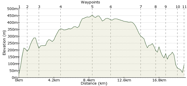
Ascent
446m (1463ft)
Descent
379m (1243ft)
Max. Elevation
460m (1509ft)
Altitude Gain & Loss
825m (2706ft)
Start & End
Lynton
Distance
20.00km
(12.43mi)
(12.43mi)
Duration
~7:15h
Difficulty
Strenuous
Ordnance Survey Map
Exmoor is great for moorland walking - a short distance from the coastal towns are huge tracts of moorland, where you can walk all day and only meet those little ponies. A great place to get a taste of Exmoor's wilder side is to explore the region around Exe Plain and Cheriton Ridge. The walk starts in Lynton and follows the Tarka Trail on to the higher ground, before crossing the moor and descending via the East Lyn River valley. It's a long day out, so pack plenty of sandwiches.
Walk Functions
Share
Nearby Walks
Exmoor's extraordinary coastline Part II
A moderate, linear walk (coast) starting in Devon, England, about 18.10km (11.25 mi) long, duration: ~7:15h.Lynton & Lynmouth
A leisurely, circular walk (coast) starting in Devon, England, about 5.70km (3.54 mi) long, duration: ~2:15h.Cosgate Hill to Countisbury
A moderate, circular walk (coast) starting in Devon, England, about 12.40km (7.71 mi) long, duration: ~4:30h.Walk Map
- $walk->POI array(0)
Waypoints
OS Grid SS724494
Start at Lynton, which has good bus connections. Across the river from the town centre is the start of both the Two Moors Way and the Tarka Trail - just near the craft centre.
OS Grid SS732486
After a steep climb up Lyn Cleave, the path follows the top of Wester Wood, which crowds around the East Lyn River. Carry along the two trails past Myrtleberry Cleave.
About 1.13 km (~0.7 miles) from 
OS Grid SS741477
The path crosses a road at Combe Park Wood and follows a woody valley for a short distance. At Smallcombe Bridge, the route climbs upwards again to the hamlet of Cheriton.
About 1.27 km (~0.79 miles) from 
OS Grid SS744452
The path climbs out on to open moorland past Cheriton, and it's now time to really stretch those legs. Follow the Cheriton Ridge on to the higher ground.
About 2.52 km (~1.57 miles) from 
OS Grid SS752415
The trail will take you to a footpath junction - more like an intersection - high on the moors at Exe Head. Take a bearing towards Exe Plain to the northeast - you leave the path here, so map and compass at the ready. It's Access Land, prime for wandering, but keep on the northeasterly bearing.
About 3.78 km (~2.35 miles) from 
OS Grid SS765434
Carry across to Hoar Tor, where the B3223 cuts across the moor. If the weather is bad, this road proves a useful handrail back to the valley. But if it's fine, head away over the rough land to Brendon Common and Shilstone Hill.
About 2.30 km (~1.43 miles) from 
OS Grid SS762468
A path cuts north-south across Shilstone Hill, leading into the hamlet of the same name. Follow this down to Rockford on the bank of the East Lyn River. Fantastic little country pub here - the Rockford Inn - and well worth patronising.
About 3.41 km (~2.12 miles) from 
OS Grid SS754485
This has to be one of the most pleasant walk endings there is - along the thickly wooded, steep-sided valley of the East Lyn River. There are paths on either side; my tip would be the path on the eastern side, so cross the footbridge outside the pub.
About 1.86 km (~1.16 miles) from 
OS Grid SS744487
The path takes you past the impressive National Trust property of Watersmeet House - what a place to live!
About 1.07 km (~0.66 miles) from 
OS Grid SS730491
The path continues through Wester Wood back to Lynton.
About 1.39 km (~0.86 miles) from 
 Lynton again
OS Grid SS722493
Back to Lynton for the bus onwards, or maybe just a cream tea and a dip in the sea.
About 0.90 km (~0.56 miles) from 

2 comments... join the discussion!
patrikG
Forced relocation? Not with Car Free Walks! Lynton is now back where it belongs: in Devon. :) Well spotted.
Caroline
Oh dear, a county calamity! If you're still doing this website please can you put Lynton in the right county? We are of course in beautiful Devon :-)