Ben Oss and Beinn Dubhchraig
A moderate walk (mountain (above 600m)) in Argyll and Bute, Scotland, about 18.10km (11.25 mi) long with an estimated walking time of about 8:15h (1 overnight stay). It is unsuitable for families with children, prams & pushchairs, wheelchairs.
Elevation Profile
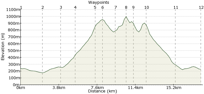
Ascent
1007m (3303ft)
Descent
1017m (3336ft)
Max. Elevation
1000m (3280ft)
Altitude Gain & Loss
2024m (6639ft)
Start & End
Lower Tyndrum Station
Distance
18.10km
(11.25mi)
(11.25mi)
Duration
~8:15h
Difficulty
Moderate
Ordnance Survey Map
These two mountains are a good day out in the Tyndrum Hills. From Lower Tyndrum station, it's a bit of a walk-in before you gain the height of Beinn Dubhchraig and the fantastic views over to Crianlarich and beyond. Tyndrum is a good base for further exploration of the area as well.
Walk Functions
Share
Nearby Walks
Ben Lui from Tyndrum
A moderate, circular walk (mountain (above 600m)) starting in Stirlingshire, Scotland, about 15.70km (9.76 mi) long, duration: ~7:00h.Beinn Odhar and Meall Buidhe
A moderate, circular walk (mountain (above 600m)) starting in Stirlingshire, Scotland, about 8.50km (5.28 mi) long, duration: ~4:00h.Cruach Ardrain and Beinn Tulaichean
A moderate, circular walk (mountain (above 600m)) starting in Stirlingshire, Scotland, about 13.60km (8.45 mi) long, duration: ~6:30h.Walk Map
- $walk->POI array(0)
Waypoints
OS Grid NN327302
Tyndrum has two stations - you need the lower one. There are also buses to the village centre. From the station, pick up the West Highland Way heading south.
OS Grid NN345288
Just beyond Dalrigh, a bridge crosses the River Cononish and heads west along the railway line. After 1km, it crosses the railway line.
About 2.27 km (~1.41 miles) from 
OS Grid NN331277
The path passes through a small patch of ancient Caledonian woodland, before another bridge takes you across the Allt Gleann Auchreoch.
About 1.78 km (~1.11 miles) from 
OS Grid NN318273
Use the Allt Coire Dubhcraig to guide you through the forest plantation, before you reach the open ground of the mountain's lower slopes.
About 1.33 km (~0.83 miles) from 
OS Grid NN304259
Pick your way up into the corrie, before gaining the ridge of Beinn Dubhcraigh. Look for a cluster of small pools, which mark the ridge proper.
About 2.02 km (~1.26 miles) from 
OS Grid NN308255
The summit is 500m southeast of the pools - a Munro at 978m. Once you have had a sandwich, return along the ridge and continue past the pools towards Ben Oss.
About 0.57 km (~0.35 miles) from 
OS Grid NN296259
It's a steep drop into the bealach between the peaks, followed by a steady pull onto Ben Oss.
About 1.22 km (~0.76 miles) from 
OS Grid NN288253
The ridge continues in a curve, high above Loch Oss, onwards to the summit of Ben Oss at 1029m. There are great views south over the Crianlarich Hills, and into the dramatic corrie of Beinn Laoigh.
About 1.03 km (~0.64 miles) from 
OS Grid NN291259
It's possible to drop down the steep northwest slope from Ben Oss to the Allt Coire Laoigh, and then to continue via the Cononish track. However, this is a longer option; a quicker, and probably more enjoyable option is to retrace your steps along the ridge.
About 0.69 km (~0.43 miles) from 
OS Grid NN303258
At the pools, return back down via the corrie and pick up the path along the burn.
About 1.23 km (~0.76 miles) from 
OS Grid NN326276
Head back through the woods and to Dalrigh.
About 2.86 km (~1.78 miles) from 
 Back to Tyndrum
OS Grid NN330302
Return via the same tracks to Tyndrum. There's a great campsite just by Lower Tyndrum Station, plus a good pub and shop in the village itself.
About 2.56 km (~1.59 miles) from 
