The Lowther Hills
A leisurely walk (mountain (above 600m)) in Dumfries and Galloway, Scotland, about 8.60km (5.34 mi) long with an estimated walking time of about 3:30h. It is unsuitable for families with children, prams & pushchairs, wheelchairs.
Elevation Profile
Ascent
337m (1105ft)
Descent
318m (1043ft)
Max. Elevation
730m (2395ft)
Altitude Gain & Loss
655m (2148ft)
Start & End
Wanlockhead
Distance
8.60km
(5.34mi)
(5.34mi)
Duration
~3:30h
Difficulty
Leisurely
Ordnance Survey Map
The Lowther Hills are the highest section of the Southern Upland Way, and make for some of the best walking in the region. The fells are easy to ascend, with vast grassy slopes. Wanlockhead, an old mining village that is Scotland's highest at 1531 feet makes the ideal base. Buses run to Sanquhar, which has a train station.
Walk Functions
Share
Nearby Walks
The Pentland Hills
A moderate, linear walk (low hills and fells (below 600m)) starting in Midlothian, Scotland, about 12.70km (7.89 mi) long, duration: ~4:30h.Ancient forts on the Dumfries coastline
A leisurely, linear walk (coast) starting in Dumfries and Galloway, Scotland, about 7.90km (4.91 mi) long, duration: ~2:15h.River North Esk Circular
A leisurely, circular walk (woodland) starting in Midlothian, Scotland, about 5.20km (3.23 mi) long, duration: ~1:30h.Walk Map
- $walk->POI array(0)
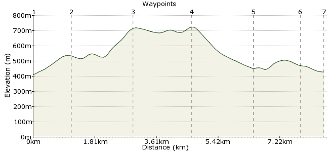
Waypoints
OS Grid NS873127
Take the bus to Wanlockhead, an old mining village sat in the Mennock Pass. Head for the Visitor Centre in the village; behind here are signs for the Southern Upland Way.
OS Grid NS885123
As you reach Stake Hill, look for the tracking heading south (away from the SUW). This leads to Lowther Hill.
About 1.20 km (~0.75 miles) from 
OS Grid NS889107
The path zigzags up the western side of Lowther Hill, which reaches 725m. Fantastic views from the summit.
About 1.72 km (~1.07 miles) from 
OS Grid NS900119
A track leads from Lowther Hill towards Green Lowther, seven metres higher at 732m.
About 1.63 km (~1.01 miles) from 
OS Grid NS893136
Descend Green Lowther via the northwestern ridge, down to the old mine workings. Mining was once big business around here - there is even gold found in the hills.
About 1.79 km (~1.11 miles) from 
OS Grid NS880133
Paths will lead you back towards the B797, which runs to Wanlockhead.
About 1.40 km (~0.87 miles) from 
 The village again
OS Grid NS876128
Back to the village, where buses, accommodation and pubs await - the Wanlockhead Inn is a good bet: wanlockheadinn.com
About 0.61 km (~0.38 miles) from 
