Applethwaite Common and Sleddale Forest
A moderate walk (low hills and fells (below 600m)) in national park Lake District starting and finishing in Cumbria, England, about 17.40km (10.81 mi) long with an estimated walking time of about 6:45h. It is unsuitable for families with children, prams & pushchairs, wheelchairs.
Elevation Profile
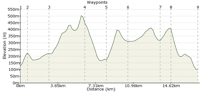
Ascent
555m (1820ft)
Descent
583m (1912ft)
Max. Elevation
510m (1673ft)
Altitude Gain & Loss
1138m (3732ft)
Start
Windermere Station
End
Staveley Station
Distance
17.40km
(10.81mi)
(10.81mi)
Duration
~6:45h
Difficulty
Moderate
Ordnance Survey Map
This walk traverses the area between Windermere and Kentmere - often overlooked in the race for the big peaks. From Windermere Station, head over Orrest Head to pick up the Dubbs Road around Applethwaite Common. The road leads to Kentmere Village, from where you can head on tto Staveley Head Fell and Brunt Knott before picking up the train at Staveley.
Walk Functions
Share
Nearby Walks
Troutbeck valley - the first car-free walk!
A moderate, linear walk (mountain (above 600m)) starting in Cumbria, England, about 18.90km (11.74 mi) long, duration: ~7:30h.3 Day Leisurely Jaunt around the Lakes
A leisurely, walk (low hills and fells (below 600m)) starting in Cumbria, England, about 8.00km (4.97 mi) long, duration: ~3:30h.The Ill Bell Ridge and High Street
A moderate, linear walk (mountain (above 600m)) starting in Cumbria, England, about 16.50km (10.25 mi) long, duration: ~7:00h.Walk Map
- $walk->POI array(0)
Waypoints
OS Grid SD414985
From the station, cross the road and take the track heading towards Orrest Head (across the junction).
OS Grid SD414993
The path heads over Orrest Head and through Near Orrest. Pick up the Dubbs Road just beyond the hamlet.
About 0.75 km (~0.47 miles) from 
OS Grid NY423012
The Dubbs Road will lead you round towards Kentmere, with fantastic views into Troutbeck Valley as you go.
About 2.05 km (~1.27 miles) from 
OS Grid NY438043
The descent to Kentmere is via the craggy Garburn Pass.
About 3.44 km (~2.14 miles) from 
OS Grid NY459041
Pass through Kentmere and head for the opposite side of the valley. A bridleway signposted to Cocklaw Fell points out your way.
About 2.07 km (~1.29 miles) from 
OS Grid NY478034
This is a lonely little tarn, up on the summit ridge of Green Quarter Fell. Keep on along the crest towards Sleddale Forest.
About 2.06 km (~1.28 miles) from 
OS Grid NY494008
Cross a stream via a footbridge and head for Brunt Knott.
About 3.04 km (~1.89 miles) from 
OS Grid NY485006
The summit is marked by a trig point. From here, head for Brunt Knott Farm and follow the path down to Hall Lane.
About 0.92 km (~0.57 miles) from 
 Staveley
OS Grid SD470983
Finish in the small town of Staveley. The Hawkeshead Brewery is well worth a visit - just near the station.
About 2.69 km (~1.67 miles) from 
