Brockenhurst Circular
A moderate walk (woodland) in national park New Forest in Hampshire, England, about 14.50km (9.01 mi) long with an estimated walking time of about 4:15h. It is unsuitable for families with children, prams & pushchairs, wheelchairs.
Elevation Profile
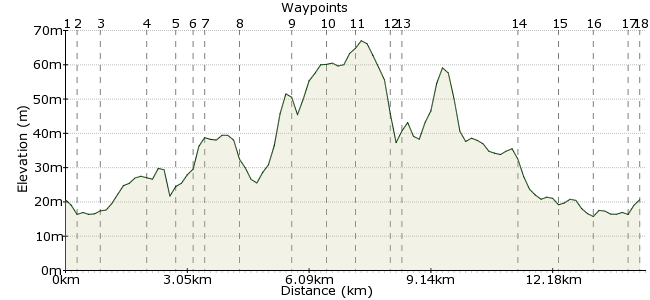
Ascent
56m (183ft)
Descent
56m (183ft)
Max. Elevation
70m (229ft)
Altitude Gain & Loss
112m (366ft)
Start & End
Brockenhurst Station
Distance
14.50km
(9.01mi)
(9.01mi)
Duration
~4:15h
Difficulty
Moderate
Ordnance Survey Map
 Car Free Walks TeamCreated by GaryShipp on 19 May 2010
A beautiful walk in the heart of the New Forest, taking in some of the variety of the area. Can be done in half a day, but more likely a little longer to give ample excuse for a cafe stop at the end.
Walk Functions
Share
Nearby Walks
Looking for ponies near Brockenhurst
A leisurely, circular walk (woodland) starting in Hampshire, England, about 6.30km (3.91 mi) long, duration: ~1:45h.Wilverley Common in the New Forest
A leisurely, linear walk (woodland) starting in Hampshire, England, about 8.90km (5.53 mi) long, duration: ~2:45h.Fulliford Bog in the New Forest
A leisurely, linear walk (woodland) starting in Hampshire, England, about 4.60km (2.86 mi) long, duration: ~1:15h.Walk Map
- $walk->POI array(0)
Waypoints
OS Grid SU301020
Start of the walk
OS Grid SU298022
Take the chance to stokc up on provisions in the village shops. the bakers / deli on the right hand side of the road is something else!
About 0.38 km (~0.24 miles) from 
OS Grid SU293020
Leave the road here and gain the bridleway. Skirt below the residences, heading west.
About 0.58 km (~0.36 miles) from 
OS Grid SU284025
From this point you can head where you choose across the common land of White Moor to your left.
About 1.04 km (~0.65 miles) from 
OS Grid SU281030
When you have crossed the footbridge, turn left along the path.
About 0.61 km (~0.38 miles) from 
OS Grid SU276030
Turn right here (north) where you meet a path cutting across.
About 0.45 km (~0.28 miles) from 
OS Grid SU276031
Turn left (west) along this wide track
About 0.17 km (~0.11 miles) from 
OS Grid SU268033
Head straight on, taking the path round Clumber Inclosure.
About 0.82 km (~0.51 miles) from 
OS Grid SU260024
The heady heights of Holn Hill (55) offer fine views of the surrounding area.
About 1.22 km (~0.76 miles) from 
OS Grid SU256017
A broad track will bring you towards a road. As you reach a wider open area, come off the main path and head SW across Wilverley Plain towards the enclosure.
About 0.81 km (~0.5 miles) from 
OS Grid SU253010
Find the path into the Inclosure.
About 0.76 km (~0.47 miles) from 
OS Grid SU252002
Having meandered your way through the Inclosure, exit to the road near Wilverley Lodge.
About 0.78 km (~0.48 miles) from 
OS Grid SZ252999
The old railway line used to pass between Brockenhurst and Ringwood. It now offers a great route back to Brockenhurst.
About 0.30 km (~0.19 miles) from 
OS Grid SU281004
Turn left (NE) towards the uninviting sounding Hincheslea Bog.
About 2.83 km (~1.76 miles) from 
OS Grid SU285012
Gain the bridleway passing below South Weirs to the road near Pound Farm.
About 0.97 km (~0.6 miles) from 
OS Grid SU291019
Here you'll be back on the road, not too far from where you left earlier. Take the road back into the village.
About 0.88 km (~0.55 miles) from 
OS Grid SU298022
Hopefully you'll have time to sample one of the cafes in the heart of the village and a well earned rest.
About 0.80 km (~0.5 miles) from 
 Station
OS Grid SU301020
Regular trains head up to Southampton and down to Bournemouth, Poole and Weymouth.
About 0.38 km (~0.24 miles) from 

2 comments... join the discussion!
Tim Woods
Hi Razouski, sorry to hear that! Walk estimates are not an exact science, I'm afraid, but hopefully you enjoyed the walk all the same.
Tim
Razouski
This started out as a lovely route, but we were expecting to walk between 13 and 14 km. However I had my gps mapping app on and it measured the walk at more than 17km. As a result we struggled on the last lap.