A wander over Cleeve Common
A leisurely walk (low hills and fells (below 600m)) starting and finishing in Gloucestershire, England, about 8.40km (5.22 mi) long with an estimated walking time of about 3:00h. It is unsuitable for families with children, prams & pushchairs, wheelchairs.
Elevation Profile
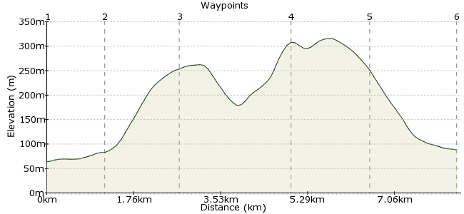
Ascent
245m (803ft)
Descent
221m (725ft)
Max. Elevation
320m (1049ft)
Altitude Gain & Loss
466m (1528ft)
Start
Gotherington
End
Cheltenham
Distance
8.40km
(5.22mi)
(5.22mi)
Duration
~3:00h
Difficulty
Leisurely
Ordnance Survey Map
There's more to do in Cheltenham than watch horses racing; just east of the town is Cleeve Common, a fantastic place for a walk. The hill curves around the town, so you can make the day as long or as short as you want. Start in Gotherington, a short bus ride away. To find out more about what you might see on the common, visit: www.cleevecommon.org.uk
Walk Functions
Share
Nearby Walks
Around the Slaughters
A moderate, circular walk (riverside) starting in Gloucestershire, England, about 10.40km (6.46 mi) long, duration: ~3:15h.Colwall to Ledbury
A moderate, linear walk (countryside) starting in Herefordshire, England, about 11.10km (6.90 mi) long, duration: ~3:30h.The Malvern Hills
A moderate, linear walk (low hills and fells (below 600m)) starting in Worcestershire, England, about 14.40km (8.95 mi) long, duration: ~5:15h.Walk Map
- $walk->POI array(0)
Waypoints
OS Grid SO964296
Start at the village of Gotherington. If you want to arrive in style, take the steam train on the Gloucestershire & Warwickshire Railway.
OS Grid SO975299
Head to the station east of the village. From here, there is a bridleway leading up Nottingham Hill.
About 1.14 km (~0.71 miles) from 
OS Grid SO982285
Most of the climbing is done on the steep slopes of Nottingham Hill - once this is done, you've got your height for the day. The hill is actually the site of an ancient fort.
About 1.48 km (~0.92 miles) from 
OS Grid SO985263
Follow the track from Nottingham Hill and cross the road. From here, pick up the Cotswold Way towards Cleeve Hill - the highest point in the Cotswolds at 330m. Just south of the summit is an iron-age long barrow.
About 2.22 km (~1.38 miles) from 
OS Grid SO987248
Keen walkers can continue along the Cotswold Way which continues to the southern side of Cheltenham. For a more leisurely day, drop down the escarpment just past Queen's Wood.
About 1.51 km (~0.94 miles) from 
 Prestbury
OS Grid SO974238
Great views of the racecourse as you descend. The path takes you into Prestbury, on the outskirts of Cheltenham. Buses run from here, or it is a further mile into the town centre.
About 1.72 km (~1.07 miles) from 
