Froggatt, Curbar and the River Derwent circular
A moderate walk (low hills and fells (below 600m)) in national park Peak District in Derbyshire, England, about 11.30km (7.02 mi) long with an estimated walking time of about 3:45h. It is unsuitable for families with children, prams & pushchairs, wheelchairs.
Elevation Profile
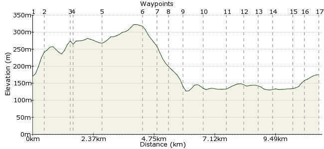
Ascent
214m (702ft)
Descent
209m (685ft)
Max. Elevation
330m (1082ft)
Altitude Gain & Loss
423m (1387ft)
Start & End
Grindleford
Distance
11.30km
(7.02mi)
(7.02mi)
Duration
~3:45h
Difficulty
Moderate
Ordnance Survey Map
 Car Free Walks TeamCreated by GaryShipp on 26 Jun 2010
This route takes in the contrasting landscapes of the Girtstone edges, with the softer pastoral views of a riverside walk.
Walk Functions
Share
Nearby Walks
Padley Gorge and Longshaw Estate
A leisurely, circular walk (low hills and fells (below 600m)) starting in Derbyshire, England, about 4.50km (2.80 mi) long, duration: ~1:30h.Grindleford to Hathersage - the Hard(er) Way
A moderate, linear walk (low hills and fells (below 600m)) starting in Derbyshire, England, about 10.80km (6.71 mi) long, duration: ~4:00h.Stanage Edge, Carl Wark and Higger Tor
A moderate, circular walk (low hills and fells (below 600m)) starting in Derbyshire, England, about 11.90km (7.39 mi) long, duration: ~4:15h.Walk Map
- $walk->POI array(0)
Waypoints
OS Grid SK249788
Start of the walk
OS Grid SK251784
From the housing estate road, take the footpath heading across the slope towards Hay Wood.
About 0.45 km (~0.28 miles) from 
OS Grid SK254775
Take care crossing the road here as speedy cars can catch you unaware on these bends.
About 0.91 km (~0.57 miles) from 
OS Grid SK253775
This well worn path now takes you towards and above the Gritstone edges.
About 0.13 km (~0.08 miles) from 
OS Grid SK248766
An extremely popular climbing venue with some of the best slab climbing in the area. Join the rock athletes below, or simply marvel from a respectful distance.
About 1.09 km (~0.68 miles) from 
OS Grid SK256754
This log edge is a little less busy than it's neighbour, but offers beautiful views and secluded buttreses to explore.
About 1.41 km (~0.88 miles) from 
OS Grid SK257748
Choose your path from the top of the crag down to the road near Warren Lodge.
About 0.58 km (~0.36 miles) from 
OS Grid SK253746
Curbar suffered from the Great Plague in the 17th century in much the same way as Eyam, though about 30 years earlier. On the moors there are the gravestones of the Cundy family who lived at Grislowfield farm, Curbar.
About 0.47 km (~0.29 miles) from 
OS Grid SK248747
The return route along the banks of the river offers a lovely contrast to the moorland edges above. keep your eyes out for birdlife, the names of which you may or may not know.
About 0.48 km (~0.3 miles) from 
OS Grid SK243753
Again, take care of speeding drivers.
About 0.76 km (~0.47 miles) from 
OS Grid SK243762
The name Froggatt derives from the fact that there were originally 17 fresh water springs situated in the village, three of which can still be seen.
About 0.86 km (~0.53 miles) from 
OS Grid SK243768
This ancient track takes you towards the edge of the imposing looking woodland.
About 0.65 km (~0.4 miles) from 
OS Grid SK245773
Depending on the time of year you visit, a myriade of woodland smells may great you as you make your way along the path.
About 0.53 km (~0.33 miles) from 
OS Grid SK245777
From here you can turn left to the village of Grindleford and some refreshments at the local Inn.
About 0.44 km (~0.27 miles) from 
OS Grid SK242785
Turn right up the hill towards the railway line.
About 0.74 km (~0.46 miles) from 
OS Grid SK243789
Turn right and then right again after you have across the railway line via the footbridge. This path takes you back to the station.
About 0.41 km (~0.25 miles) from 
 Grindleford Station
OS Grid SK249788
To await your lift home . . .
About 0.55 km (~0.34 miles) from 
