Across the Divide - Hope to Edale
A leisurely walk (low hills and fells (below 600m)) in national park Peak District starting and finishing in Derbyshire, England, about 8.60km (5.34 mi) long with an estimated walking time of about 3:15h. It is unsuitable for families with children, prams & pushchairs, wheelchairs.
Elevation Profile
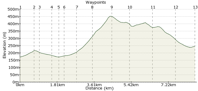
Ascent
330m (1082ft)
Descent
256m (839ft)
Max. Elevation
460m (1509ft)
Altitude Gain & Loss
586m (1921ft)
Start
Hope Valley
End
Edale
Distance
8.60km
(5.34mi)
(5.34mi)
Duration
~3:15h
Difficulty
Leisurely
Ordnance Survey Map
 Car Free Walks TeamCreated by GaryShipp on 26 Jun 2010
This short walk traverses border land between the limestone dales of the White Peak and the rocky edges and pit hags of the Dark Peak. A short up and down route, the hard work of the ascent is rewarded with fine 360 degree views.
Walk Functions
Share
Nearby Walks
The Hope Valley Skyline Walk southern half
A moderate, linear walk (low hills and fells (below 600m)) starting in Derbyshire, England, about 16.70km (10.38 mi) long, duration: ~6:15h.Ladybower, Win Hill & Hope
A leisurely, linear walk (low hills and fells (below 600m)) starting in Derbyshire, England, about 9.00km (5.59 mi) long, duration: ~3:15h.Ladybower from Bamford via High Neb
A moderate, circular walk (low hills and fells (below 600m)) starting in Derbyshire, England, about 18.70km (11.62 mi) long, duration: ~6:30h.Walk Map
- $walk->POI array(0)
Waypoints
OS Grid SK180832
Start of the walk
OS Grid SK181839
Take the footpath from the station to the small hamlet of Aston.
About 0.69 km (~0.43 miles) from 
OS Grid SK179837
Turn right off the road towards Farfield Farm.
About 0.29 km (~0.18 miles) from 
OS Grid SK174839
Cross the railway line.
About 0.60 km (~0.37 miles) from 
OS Grid SK171839
Head straight over the road and up th track and then turn right.
About 0.25 km (~0.16 miles) from 
OS Grid SK168840
Taking note to observe the maximum carrying capcity of the structure . . . !
About 0.30 km (~0.19 miles) from 
OS Grid SK164842
Take the right hand fork, heading past Lose Hill Farm to Losw Hill.
About 0.51 km (~0.32 miles) from 
OS Grid SK158846
Go round the farm, taking care to close all gates.
About 0.74 km (~0.46 miles) from 
OS Grid SK153853
Your first site of Edale Valley, with the dark broading High Peak behind.
About 0.84 km (~0.52 miles) from 
OS Grid SK145849
A great picnic spot as it is possible to find shelter from most wind directions in some little nook. To the south you will see the remains of Peveril Castle, mentioned in the Doomsday Book.
About 0.86 km (~0.53 miles) from 
OS Grid SK135845
Unfortunately the cross no longer exists, but it marks the lowest point in the ridge between the valley of Castleton and Edale. This well troden path has been used for centuries.
About 1.05 km (~0.65 miles) from 
OS Grid SK125844
Find the road heading downhill.
About 1.05 km (~0.65 miles) from 
 Edale Station
OS Grid SK122853
The end of the walk. The Rambler Pub next door offers warmth and refreshments should you need either. If you have time or inclination, 1km further along is Grindsbrook Booth where the smore characterful Old Nags Head will do similar.
About 0.96 km (~0.6 miles) from 
