Burbage Moor and back from Whirlow Bridge
A moderate walk (countryside) in national park Peak District in Derbyshire, England, about 14.10km (8.76 mi) long with an estimated walking time of about 4:45h. It is unsuitable for families with children, prams & pushchairs, wheelchairs.
Elevation Profile
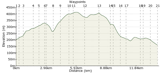
Ascent
311m (1020ft)
Descent
353m (1158ft)
Max. Elevation
420m (1377ft)
Altitude Gain & Loss
664m (2178ft)
Start & End
Whirlow Bridge
Distance
14.10km
(8.76mi)
(8.76mi)
Duration
~4:45h
Difficulty
Moderate
Ordnance Survey Map
 Car Free Walks TeamCreated by GaryShipp on 28 Jun 2010
It's amazing how quickly you can leave the suburbs of Sheffield behind and feel like you are out in the wilds, communing with nature. This walk takes you straight from The Big Shake Out campsite, up onto the eastern moors.
Walk Functions
Share
Nearby Walks
Sheffield to Stanage
A moderate, linear walk (riverside) starting in South Yorkshire, England, about 12.80km (7.95 mi) long, duration: ~4:45h.Padley Gorge and Longshaw Estate
A leisurely, circular walk (low hills and fells (below 600m)) starting in Derbyshire, England, about 4.50km (2.80 mi) long, duration: ~1:30h.Froggatt, Curbar and the River Derwent circular
A moderate, circular walk (low hills and fells (below 600m)) starting in Derbyshire, England, about 11.30km (7.02 mi) long, duration: ~3:45h.Walk Map
- $walk->POI array(0)
Waypoints
OS Grid SK312826
Start of the walk
OS Grid SK310826
Follow the track to the public car park.
About 0.22 km (~0.14 miles) from 
OS Grid SK307830
Take the path heading northwards, then turn left shortly after crossing Limb Brook. taking the path through this popular woodland.
About 0.49 km (~0.3 miles) from 
OS Grid SK300834
Just before leaving the woods, take the left hand path into the field.
About 0.81 km (~0.5 miles) from 
OS Grid SK294834
Look carefully on your map here as a number of paths cross at this point.
About 0.62 km (~0.39 miles) from 
OS Grid SK290837
The Norfolk Arms pub offers refreshment for those in need.
About 0.44 km (~0.27 miles) from 
OS Grid SK292837
Turn left off the road along the footpath.
About 0.18 km (~0.11 miles) from 
OS Grid SK291843
After walking across the open fields you will reach a lane. Turn left and then left again after crossing the stream.
About 0.59 km (~0.37 miles) from 
OS Grid SK284840
On reaching the road, turn right. After a short distance the road spilts into 3, a footpath heads roughly westerly from here across the fields, heralding the boundary of the National Park.
About 0.72 km (~0.45 miles) from 
OS Grid SK278837
From this vantage point, the moor starts to open up before you, with views of the city behind.
About 0.72 km (~0.45 miles) from 
OS Grid SK278834
Take care of speedy drivers. Cross over to the wide track on the other side of the road and take this along the edge of Lady Canning's Plantation.
About 0.32 km (~0.2 miles) from 
OS Grid SK286826
Turn right, heading across Burbage Moor.
About 1.11 km (~0.69 miles) from 
OS Grid SK276816
Turn right here, heading back easterly.
About 1.40 km (~0.87 miles) from 
OS Grid SK287815
Take care here. You'll need to cross the road and walk along it for about 400m or so.
About 1.04 km (~0.65 miles) from 
OS Grid SK286813
Turn right off the road onto the path, keeping left at the first fork after about 150m.
About 0.17 km (~0.11 miles) from 
OS Grid SK289807
Keep left here, following the course of the stream.
About 0.73 km (~0.45 miles) from 
OS Grid SK295807
Exit the woods onto Shorts Lane and head along it in a vagulely Easterly, then NE direction. At the end turn right and then keep straight on into Townhead.
About 0.52 km (~0.32 miles) from 
OS Grid SK307811
Turn up the lane here, heading nothwards.
About 1.35 km (~0.84 miles) from 
OS Grid SK307812
Head up this road.
About 0.11 km (~0.07 miles) from 
OS Grid SK308819
Take the lane on the right here for a worthwhile extra little distance via the woods, or carry straight on up the road back to the campsite.
About 0.70 km (~0.43 miles) from 
 Woodland path junction
OS Grid SK315819
Turn left here on the obvious track back to the campsite.
About 0.74 km (~0.46 miles) from 
