Carn a' Mhadaidh-ruidh - a route around Lochaber
A moderate walk (low hills and fells (below 600m)) starting and finishing in Highland, Scotland, about 12.40km (7.71 mi) long with an estimated walking time of about 5:00h. It is unsuitable for families with children, prams & pushchairs, wheelchairs.
Elevation Profile
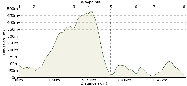
Ascent
443m (1453ft)
Descent
510m (1673ft)
Max. Elevation
490m (1607ft)
Altitude Gain & Loss
953m (3126ft)
Start
Beasdale Station
End
Arisaig Station
Distance
12.40km
(7.71mi)
(7.71mi)
Duration
~5:00h
Difficulty
Moderate
Ordnance Survey Map
The hills of Lochaber offer some fantastic low-level walking. This route follows a rough track past lochans and crags to the summit of Carn a' Mhadaidh-ruidh. From there, it heads to the shores of Loch Morar before returning to Arisaig. It's a lonely old spot - perfect for a day away from it all. Don't be fooled by the lack of height - if the weather turns bad, the surroundings quickly become hard to navigate. But I can guarantee you'll have the hills to yourself, save for the deer.
Walk Functions
Share
Nearby Walks
Port nam Murrach beach from Arisaig
A moderate, circular walk (coast) starting in Highland, Scotland, about 13.00km (8.08 mi) long, duration: ~4:00h.The Corbetts of the Moidart peninsular
A moderate, circular walk (mountain (above 600m)) starting in Highland, Scotland, about 13.70km (8.51 mi) long, duration: ~6:30h.The lost village of Peanmeanach
A moderate, circular walk (low hills and fells (below 600m)) starting in Highland, Scotland, about 12.40km (7.71 mi) long, duration: ~4:30h.Walk Map
- $walk->POI array(0)
Waypoints
OS Grid NM708850
Ask the conductor to stop at Beasdale. Even as you step off the platform, it feels a long way from the middle of nowhere. Head west along the road for about 800m to Borrodale House.
OS Grid NM696852
Opposite Borrodale House, a track leads into the woods. It heads uphill - over the railway tunnel through the hill - and follows the Borrodale Burn.
About 1.20 km (~0.75 miles) from 
OS Grid NM711875
The track reaches Lochan a Bhealaich, right in the heart of Lochaber. Seen anyone else yet?
About 2.86 km (~1.78 miles) from 
OS Grid NM706886
Just beyond Lochan Fada, you will need to leave the main track and head cross-country up to the summit of Carn a' Mhadaidh-ruaidh. 503m high - not a Corbett or a Munro, so we'll call it a 'Tim'. From here, drop down the northern shoulder back to the track.
About 1.19 km (~0.74 miles) from 
OS Grid NM701901
Continue on to lonely Scamadale, just near the shores of Loch Morar. Enjoy the lunchtime sarnies with views across to North Morar.
About 1.53 km (~0.95 miles) from 
OS Grid NM683895
From Scamadale, a vehicle track heads through the woods and on to Sunisletter. From here, it runs along the railway for a while.
About 1.89 km (~1.17 miles) from 
OS Grid NM675885
At Craigmore Cottage, the track crosses the railway. Continue on to Kinloid, just north of Arisaig.
About 1.28 km (~0.8 miles) from 
 Arisaig
OS Grid NM663865
Head into Arisaig, where you can catch the train or bus back home.
About 2.27 km (~1.41 miles) from 
