Picws Du and Fan Brycheiniog - the Black Mountain
A moderate walk (mountain (above 600m)) in national park Brecon Beacons in Powys, Wales, about 18.40km (11.43 mi) long with an estimated walking time of about 7:00h. It is unsuitable for families with children, prams & pushchairs, wheelchairs.
Elevation Profile
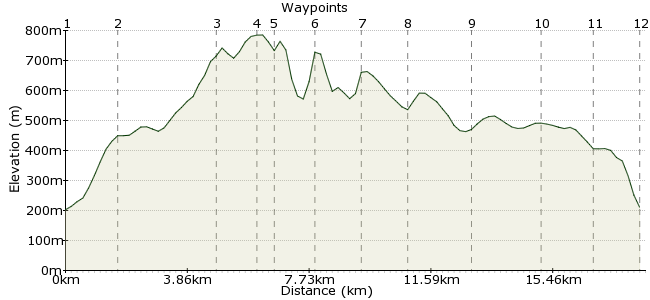
Ascent
607m (1991ft)
Descent
600m (1968ft)
Max. Elevation
790m (2591ft)
Altitude Gain & Loss
1207m (3959ft)
Start & End
Glyntawe
Distance
18.40km
(11.43mi)
(11.43mi)
Duration
~7:00h
Difficulty
Moderate
Ordnance Survey Map
This is my favourite walk in the Brecon Beacons; the view across the north face of the sandstone escarpment from Fan Foel is the finest in South Wales. The long ridge of Fan Hir also makes for a fine hour of walking on the journey in. It's a fair old walk, too: Fan Brycheiniog is 802m. Start from Glyntawe, which is a bustling little town thanks to the nearby Dan-yr-Ogof caves. Buses running between Brecon and Ystredgynlais stop at Glyntawe; the nearest train station is Ammanford.
Walk Functions
Share
Nearby Walks
Waterfalls galore in the Brecon Beacons
A moderate, circular walk (riverside) starting in Neath Port Talbot (Castell-nedd Port Talbot), Wales, about 11.30km (7.02 mi) long, duration: ~3:45h.Fan Fawr from Storey Arms
A moderate, circular walk (mountain (above 600m)) starting in Powys, Wales, about 19.00km (11.81 mi) long, duration: ~7:15h.Pen Y Fan Horseshoe
A moderate, linear walk (mountain (above 600m)) starting in Powys, Wales, about 16.20km (10.07 mi) long, duration: ~6:15h.Walk Map
- $walk->POI array(0)
Waypoints
OS Grid SN843162
Start in the village of Glyntawe. From the bus stop, head up the road towards the Tafarn-y-Garreg pub. On the opposite side of the road is a footpath, which quickly crosses the river into Ty Hendrey farm. Follow the path uphill through the farm and onto the lower slopes of Allt Fach.
OS Grid SN842179
After a steep start, the slope levels out a little more and the dramatic ridge of Fan Hir stands out in front.
About 1.70 km (~1.06 miles) from 
OS Grid SN831207
It's surely the finest ridge in South Wales - not knife-edge or nerve-wracking, but 3km of easy plodding with fantastic views down the eastern face of the escarpment.
About 3.02 km (~1.88 miles) from 
OS Grid SN825218
The highest point of the day is Fan Brycheiniog, 802m high. Lovely views down to Llyn y Fan Fawr. I recommend this as your first lunch/tea stop.
About 1.24 km (~0.77 miles) from 
OS Grid SN821223
Best view of the day comes from the outpost of Fan Foel - gaze west across the corrie of Llyn y Fan Fach and the cliffs of Bannau Sir Gaer.
About 0.68 km (~0.42 miles) from 
OS Grid SN811217
Continue along around the ridge to Picws Du (749m).
About 1.19 km (~0.74 miles) from 
OS Grid SN797214
Keep on to the end of the clifftop at Waun Lefrith. From here, take a bearing towards the bridleway junction near Pen-Rhiw-goch. Note - in poor visibilty, this is where the terrain gets tricky, as it is open moorland. If it's really bad, consider retracing your steps to use the ridge as a handrail.
About 1.45 km (~0.9 miles) from 
OS Grid SN786208
The bridleway runs right across the moor back to Glyntawe. Make sure you take the right path - the southeast fork is the one to take, rather than the one heading south.
About 1.32 km (~0.82 miles) from 
OS Grid SN803197
Cross the stream and keep heading southeast.
About 2.02 km (~1.26 miles) from 
OS Grid SN820183
The path weaves through an area of shake holes, with several peat hags and bogy conditions underfoot. If time and weather permit, take in the minor tops of Carreg Goch (558m) for another fine view down to the Afon Giedd valley.
About 2.18 km (~1.35 miles) from 
OS Grid SN833174
Final detour of the day - leave the path briefly to look down the Cwm Haffes valley.
About 1.63 km (~1.01 miles) from 
 Glyntawe campsite
OS Grid SN841162
Follow the bridleway past the Glyntawe campsite into the village for a well-earned pot of tea.
About 1.46 km (~0.91 miles) from 

1 comment... join the discussion!
Paul mortimer
Did this walk on Good Friday weather was amazing really made the day All grid refs and notes are spot on Great walk, keeps you away from the crowds The walk up along the ridge is a stunner and really makes you feel out there Took us 7hrs total but that was at a relaxed pace Recommended to all