The Brecon Beacons' big three from Storey Arms
A moderate walk (mountain (above 600m)) in national park Brecon Beacons in Powys, Wales, about 15.10km (9.38 mi) long with an estimated walking time of about 6:30h. It is unsuitable for families with children, prams & pushchairs, wheelchairs.
Elevation Profile
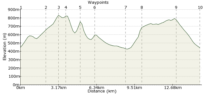
Ascent
748m (2454ft)
Descent
752m (2467ft)
Max. Elevation
840m (2755ft)
Altitude Gain & Loss
1500m (4921ft)
Start & End
Storey Arms centre
Distance
15.10km
(9.38mi)
(9.38mi)
Duration
~6:30h
Difficulty
Moderate
Ordnance Survey Map
For many people, the three peaks of Corn Du, Pen y Fan and Cribyn define the Brecon Beacons. There's several ways to tackle the hills, but I think the finest is from the Storey Arms centre on the A470. Buses between Merthyr Tydfil and Brecon all stop here, so there's reall no excuse for using the car. This route heads up to Corn Du on the Y Gyrn path and follows the main ridge path, before dropping down to Upper Neuadd Reservoir and the narrow Rhiw yr Ysgyfarnog.
Walk Functions
Share
Nearby Walks
Pen Y Fan Horseshoe
A moderate, linear walk (mountain (above 600m)) starting in Powys, Wales, about 16.20km (10.07 mi) long, duration: ~6:15h.Fan Fawr from Storey Arms
A moderate, circular walk (mountain (above 600m)) starting in Powys, Wales, about 19.00km (11.81 mi) long, duration: ~7:15h.Circuit in Central Beacons, including Fan y Big
A moderate, walk (mountain (above 600m)) starting in Powys, Wales, about 10.60km (6.59 mi) long, duration: ~4:00h.Walk Map
- $walk->POI array(0)
Waypoints
OS Grid SN983202
Pick up the footpath just next to the centre car park. Follow the path as it climbs steadily on to Y Gyrn.
OS Grid SN998218
The path curves round near the summit to join the path from Pen Milan. Follow Craig Cwm Llwch towards Corn Du.
About 2.19 km (~1.36 miles) from 
OS Grid SO007211
First summit of the day is Corn Du at 873m.
About 1.08 km (~0.67 miles) from 
OS Grid SO012213
It's a short hop from Corn Du to Pen y Fan, the day's highest point at 886m. Classic high-level walking.
About 0.53 km (~0.33 miles) from 
OS Grid SO023213
Head along Craig Cwm Sere to the summit of Cribyn. Continue along beyond the summit, with Craig Cwm Cynwyn as your guide.
About 1.18 km (~0.73 miles) from 
OS Grid SO032205
At the drop between Cribyn and Fan y Big, you can choose to take in the fourth top or follow the bridleway down to the reservoir.
About 1.06 km (~0.66 miles) from 
OS Grid SO031179
Cross the dam at the southern end of the Lower Neuadd Reservoir and take the path heading steeply up the opposite bank of the valley. It's a fair old slog - 200m of height to gain.
About 2.62 km (~1.63 miles) from 
OS Grid SO019184
More ridge walking to finish off. Head northwest along Graig Fan Du and the narrow Rhiw yr Ysgyfarnog.
About 1.24 km (~0.77 miles) from 
OS Grid SO005208
At the dip before Corn Du, take the path heading southwest down the slope towards the road.
About 2.85 km (~1.77 miles) from 
 Back to Storey Arms
OS Grid SN988198
The path comes down on the opposite side of the conifer plantation, so walk the last few steps back to the bus stop.
About 1.99 km (~1.24 miles) from 
