On Ilkley Moor ...
A moderate walk (moorland) starting and finishing in West Yorkshire, England, about 14.50km (9.01 mi) long with an estimated walking time of about 5:00h. It is unsuitable for families with children, prams & pushchairs, wheelchairs.
Elevation Profile
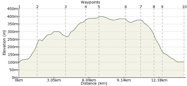
Ascent
301m (987ft)
Descent
299m (980ft)
Max. Elevation
400m (1312ft)
Altitude Gain & Loss
600m (1967ft)
Start
Burley-in-Wharfedale
End
Ilkley
Distance
14.50km
(9.01mi)
(9.01mi)
Duration
~5:00h
Difficulty
Moderate
... baht 'at. You know the song, even if you don't understand it (something about getting eaten by worms if you don't wear a hat). And when you head to Ilkley Moor, chances are you'll hear someone singing it too. And what better place for a bit of singing? It's a grand spot, the highest point of Rombalds Moor. Start at Burley-in-Wharfedale station, explore to your heart's content, and descend into Ilkley. For more information about the moor, visit: www.ilkleymoor.org
Walk Functions
Share
Nearby Walks
Otley Chevin & Caley Deer Park wander
A leisurely, circular walk (countryside) starting in Leeds, England, about 7.20km (4.47 mi) long, duration: ~2:45h.Ilkley Amble
A leisurely, circular walk (countryside) starting in Bradford, England, about 9.10km (5.65 mi) long, duration: ~2:45h.Shipley Glen
A leisurely, circular walk (countryside) starting in West Yorkshire, England, about 5.90km (3.67 mi) long, duration: ~2:00h.Walk Map
- $walk->POI array(0)
Waypoints
OS Grid SE162458
From the station, head along Moor Lane. The granite lump rises up ahead ...
OS Grid SE148450
The lane leads you out onto the moor. Follow the northern edge around the lower slopes towards Ilkley Quarry.
About 1.68 km (~1.04 miles) from 
OS Grid SE129466
The first major point of interest is Hangingstone Rocks, near Ilkley Quarry. The famous Cow and Calf rocks are here - perfect for a spot of scrabbling about!
About 2.45 km (~1.52 miles) from 
OS Grid SE125450
This is a curious stone circle, near the summit of the moor. They're quite small, but were probably important to someone back in the day.
About 1.67 km (~1.04 miles) from 
OS Grid SE115452
The summit, all 402m of it, is just west of the stone circle.
About 1.14 km (~0.71 miles) from 
OS Grid SE094457
Head beyond the Buck Stones along the crest of the moor.
About 2.13 km (~1.32 miles) from 
OS Grid SE084466
Continue past the northern edge of High Moor plantation.
About 1.35 km (~0.84 miles) from 
OS Grid SE094469
Another curiosity of the moor is the Swastika Stone, near Woodhead Crags. It's enclosed in an iron fence and one of many carved rocks on the moor, thought to date to the Bronze Age when they didn't have playstations and very much had to make their own fun.
About 1.03 km (~0.64 miles) from 
OS Grid SE100473
Return through Panorama Woods and into Ilkley via Heber's Ghyll Drive. When in Yorkshire, do as the locals do and enjoy a pint of local ale in The Bar T'at on Cunliffe Road, just near t'station.
About 0.72 km (~0.45 miles) from 
 Ilkley Station
OS Grid SE118475
Train home from Ilkley; there are also buses.
About 1.81 km (~1.12 miles) from 

2 comments... join the discussion!
Kenny_Mack
Did a similar walk myself this week in apalling weather! But the place is as good in bad weather as it is in good! I didn't get to see the 12 Apostles...that is a definite for next time!
mac.hawk
I usually do something similar but head up Hag Farm Road to reach Stocks Hill before clomping across Burley Moor to the 12 Apostles. From the trig to Whetstone Gate it is usually VERY boggy. From East Buck Stones I would NEVER descend without visiting the nearby trig at Addingham High Moor (on the TrigpointingUK website somewhat bizaarly as Overgate Croft Farm!). Makes it about 10 miles but it is a good hike.