Kyle of Lochalsh to Balmacara
A leisurely walk (coast) in Highland, Scotland, about 9.70km (6.03 mi) long with an estimated walking time of about 3:15h. It is unsuitable for families with children, prams & pushchairs, wheelchairs.
Elevation Profile
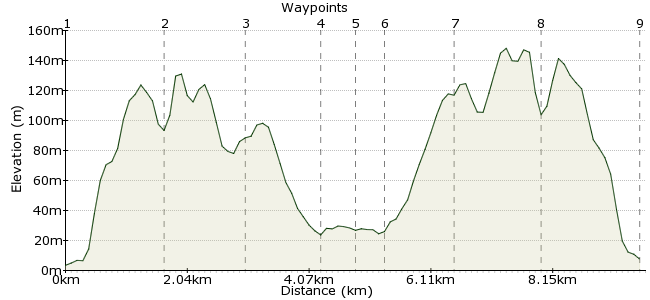
Ascent
192m (629ft)
Descent
188m (616ft)
Max. Elevation
150m (492ft)
Altitude Gain & Loss
380m (1245ft)
Start & End
Kyle of Lochalsh
Distance
9.70km
(6.03mi)
(6.03mi)
Duration
~3:15h
Difficulty
Leisurely
Ordnance Survey Maps
The rail line Inverness-Kyle of Lochalsh offers a very scenic day out. There's not a lot to do in Kyle between the first train in and last out, but 5 hours or so is just right to walk to Balmacara and back. Follow a path over NTS land through native woods and moorland, with great coast and mountain views over Skye and inland, and a handy cafe at Balmacara Square! Or alight at Plockton for a linear walk, via quiet back roads to Balmacara; allow two hours for the last 3 miles to the Kyle train!
Walk Functions
Share
Nearby Walks
Munro's big bags
A hard, circular walk (mountain (above 600m)) starting in Highlands, Scotland, about 32.50km (20.19 mi) long, duration: ~13:45h.Knoydart's headland
A strenuous, circular walk (coast) starting in Highlands, Scotland, about 20.70km (12.86 mi) long, duration: ~6:45h.Ladhar Bheinn from Inverie
A strenuous, circular walk (mountain (above 600m)) starting in Highland, Scotland, about 20.50km (12.74 mi) long, duration: ~9:00h.Walk Map
- $walk->POI array(0)
Waypoints
OS Grid NG762271
Start of the walk. Go up the slope from the station to the main road, turn right. Pass a service station on the right, turn left into Langlands Terrace, then bear right into a cul-de-sac. A signposted path leads up the hill from the end. Route finding is easy from now on!
OS Grid NG778277
The path climbs at first, then meanders between low rocky outcrops. While never in doubt, it may be bit boggy in places. A lovely section through birch woods leads down to Scalpaidh Burn, marked with a 4 way signpost, about a mile from the start.
About 1.65 km (~1.03 miles) from 
OS Grid NG791274
From the burn, the path crosses open moorland with wide-ranging loch and mountain vistas, then drops down into woodland again.
About 1.33 km (~0.83 miles) from 
OS Grid NG802278
Path emerges onto a minor road just above the A87. Turn left and the cafe is not far ahead!
About 1.17 km (~0.73 miles) from 
OS Grid NG805283
Pretty village with NTS information point, duck pond - and cafe!
http://www.nts.org.uk/Property/8/
About 0.58 km (~0.36 miles) from 
OS Grid NG803279
Return by same route. A signpost clearly marks the path's start point.
About 0.45 km (~0.28 miles) from 
OS Grid NG792275
Continue on clear path, may be boggy in places.
About 1.17 km (~0.73 miles) from 
OS Grid NG779278
Signpost - one mile to Kyle
About 1.33 km (~0.83 miles) from 
 Kyle station
OS Grid NG763272
Back into residential street, head short distance west for town centre, the rail terminus and the last train to Inverness!
About 1.70 km (~1.06 miles) from 
