Ben Ledi from Callander
A moderate walk (mountain (above 600m)) in national park Loch Lomond and the Trossachs in Stirlingshire, Scotland, about 17.30km (10.75 mi) long with an estimated walking time of about 7:15h. It is unsuitable for families with children, prams & pushchairs, wheelchairs.
Elevation Profile
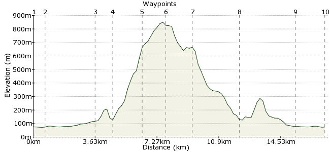
Ascent
761m (2496ft)
Descent
762m (2500ft)
Max. Elevation
860m (2821ft)
Altitude Gain & Loss
1523m (4996ft)
Start & End
Callander
Distance
17.30km
(10.75mi)
(10.75mi)
Duration
~7:15h
Difficulty
Moderate
Ordnance Survey Map
Ben Ledi is a fine hill in the wonderful Trossachs hills. It's normally approached from the A84 car park, but starting from Callander along the dismantled railway - now a national cycle route - allows you to visit the impressive Falls of Leny on the way. It adds a couple of hours to the route, but makes this great hill into a full day out.
Walk Functions
Share
Nearby Walks
Around the sights of Callander
A moderate, circular walk (low hills and fells (below 600m)) starting in Stirlingshire, Scotland, about 13.50km (8.39 mi) long, duration: ~4:45h.Beinn an t-Sidhein
A leisurely, circular walk (low hills and fells (below 600m)) starting in Stirlingshire, Scotland, about 7.40km (4.60 mi) long, duration: ~3:30h.Fawns and fairies - a Scottish family walk
A leisurely, circular walk (countryside) starting in Stirlingshire, Scotland, about 2.90km (1.80 mi) long, duration: ~1:00h.Walk Map
- $walk->POI array(0)
Waypoints
OS Grid NN630078
Take the bus to Callander to start the walk. The bakery on the high street has the best macaroni pies I have eaten in Scotland and Ben Ledi is a two-pie walk. Head west out of town along Leny Road.
OS Grid NN623080
Just off the Leny Road, the cycleway heading to Ben Ledi begins.
About 0.66 km (~0.41 miles) from 
OS Grid NN594088
Halfway along are the Falls of Leny, a marvellous waterfall where a large rock splits the river into two fast-flowing streams.
About 3.09 km (~1.92 miles) from 
OS Grid NN586093
The path up to Ben Ledi begins just beyond the waterfall. It's a well-worn path and easy to follow.
About 0.94 km (~0.58 miles) from 
OS Grid NN570088
The path climbs steadily up to the shoulder of the hill, from where it's a steady plod to the summit.
About 1.64 km (~1.02 miles) from 
OS Grid NN561099
The summit - 879m, so a little shy of Munro status.
About 1.34 km (~0.83 miles) from 
OS Grid NN558114
Continue north from the summit to Lochan nan Corp, from where a path leads down alongside Stank Glen.
About 1.53 km (~0.95 miles) from 
OS Grid NN582102
The path rejoins the railway near Loch Lubnaig. Head south, past the remains of St Bride's Chapel, and return towards Callander.
About 2.70 km (~1.68 miles) from 
OS Grid NN609083
The Lade Inn, in Kilmahog, is a great spot for a post-walk pint.
About 3.28 km (~2.04 miles) from 
 Callander
OS Grid NN626079
Back to Callander for some more pies and the bus home.
About 1.80 km (~1.12 miles) from 
