The Pewsey Downs
A moderate walk (low hills and fells (below 600m)) starting and finishing in Wiltshire, England, about 14.30km (8.89 mi) long with an estimated walking time of about 4:30h. It is unsuitable for families with children, prams & pushchairs, wheelchairs.
Elevation Profile
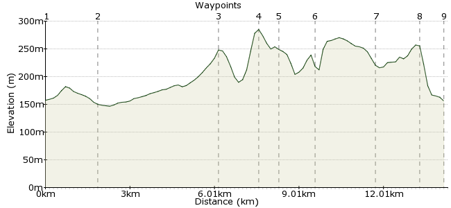
Ascent
173m (567ft)
Descent
175m (574ft)
Max. Elevation
290m (951ft)
Altitude Gain & Loss
348m (1141ft)
Start
Avebury
End
Oare
Distance
14.30km
(8.89mi)
(8.89mi)
Duration
~4:30h
Difficulty
Moderate
Ordnance Survey Map
This walk from Avebury has all the right ingredients for Wiltshire - ancient stone circles, chalk downlands, and even a White Horse, carved into the grass between Walkers Hill and Milk Hill. Both start and finish points are on the same bus route between Pewsey and Marlborough. Just north is the start of The Ridgeway long-distance path, so you know it's a good place for walking.
Walk Functions
Share
Nearby Walks
Ancient stones in Avebury
A leisurely, circular walk (countryside) starting in Wiltshire, England, about 7.00km (4.35 mi) long, duration: ~2:00h.The ancient Ridgeway
A strenuous, linear walk (low hills and fells (below 600m)) starting in Wiltshire, England, about 25.90km (16.09 mi) long, duration: ~8:00h.Two days on the Ridgeway
A hard, linear walk (countryside) starting in Wiltshire, England, about 41.50km (25.79 mi) long, duration: ~12:45h.Walk Map
- $walk->POI array(0)
Waypoints
OS Grid SU100698
Take the bus to Avebury. You need to walk to West Kennett; the quickest way is along 'Stone Avenue', also known as the B4003, but a more enjoyable way to get there is along the bridleway running to the east across Avebury Down.
OS Grid SU112683
At West Kennett, take the road running south of the village on towards West Kennett Long Barrow. At the end of the track, continue along the path.
About 1.93 km (~1.2 miles) from 
OS Grid SU092647
The path heads to Tan Hill on the Pewsey Downs. Join the White Horse Trail and follow it east.
About 4.19 km (~2.6 miles) from 
OS Grid SU103639
The path runs along the edge of the steep chalk escarpment of the downs. The south-facing slopes contain many wildflower species - I know, I had to count them for A-Level biology.
About 1.32 km (~0.82 miles) from 
OS Grid SU109635
Just beyond Milk Hill is the Alton White Horse. These things aren't quite as mystical as they look - this one was carved in 1812. What are more mysterious are the crop circles you may spot in the fields below ...
About 0.78 km (~0.48 miles) from 
OS Grid SU121636
Named after Beckham? After crossing the road, continue along the escarpment beyond Knap Hill to Golden Ball Hill.
About 1.20 km (~0.75 miles) from 
OS Grid SU141645
I think we're on the Mid Wilts Way now. Either way, just keep heading east.
About 2.20 km (~1.37 miles) from 
OS Grid SU155638
At Huish Hill, take the path dropping down to the village of Oare.
About 1.55 km (~0.96 miles) from 
 Oare
OareOS Grid SU158630
Finish in the village of Oare, and a pint in the White Hart.
About 0.85 km (~0.53 miles) from 
