Lathkill Dale from Youlgrave
A moderate walk (riverside) in national park Peak District in Derbyshire, England, about 12.30km (7.64 mi) long with an estimated walking time of about 4:00h. It is unsuitable for families with children, prams & pushchairs, wheelchairs.
Elevation Profile
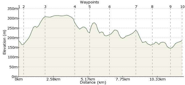
Ascent
210m (688ft)
Descent
210m (688ft)
Max. Elevation
320m (1049ft)
Altitude Gain & Loss
420m (1376ft)
Start & End
Youlgrave
Distance
12.30km
(7.64mi)
(7.64mi)
Duration
~4:00h
Difficulty
Moderate
Ordnance Survey Map
Walking and the Peaks go together like the almonds and jam in a Bakewell Pudding. The White Peak area comprises a vast limestone plateau deeply carved by several rivers. One of these – the Lathkill - cuts through the rock between Monyash and Youlgrave and provides the focal point of a great day’s walk.
Walk Functions
Share
Nearby Walks
Robin Hood's Stride and the Hermit's Cave
A leisurely, circular walk (countryside) starting in Derbyshire, England, about 2.60km (1.62 mi) long, duration: ~0:45h.Stanton Moor and the Nine Ladies
A leisurely, circular walk (countryside) starting in Derbyshire, England, about 3.70km (2.30 mi) long, duration: ~1:00h.Bakewell to Haddon Hall and back
A leisurely, circular walk (countryside) starting in Derbyshire, England, about 8.60km (5.34 mi) long, duration: ~2:45h.Walk Map
- $walk->POI array(0)
Waypoints
OS Grid SK210642
Take the bus to Youlgrave from Bakewell. From the centre, head south along Holywell Lane to the River Bradford.
OS Grid SK208639
Cross the footbridge and follow the Limestone Way west as it passes through the steep-sided river valley – a tempting hint of what’s to come.
About 0.33 km (~0.21 miles) from 
OS Grid SK194644
The Limestone Way climbs out of the valley on its northern side then heads over farmland, crossing two roads, before reaching Cales Dale.
About 1.51 km (~0.94 miles) from 
OS Grid SK172649
A very steep descent drops you into the woody dale which continues to reach the gorgeous Lathkill Dale.
About 2.23 km (~1.39 miles) from 
OS Grid SK171658
Cross the River Lathkill via the footbridge and follow the river upstream to Lathkill House Cave, where the water surges out of its underground channels in the limestone.
About 0.91 km (~0.57 miles) from 
OS Grid SK186657
Retrace your steps and continue east along the riverside footpath. Lathkill Dale is a National Nature Reserve, and keen-eyed walkers may spot wagtails, dippers and waterhens on the water, or trout weaving through the crystal waters.
About 1.47 km (~0.91 miles) from 
OS Grid SK204664
You can stop for refreshments – liquid or otherwise – at the Lathkil Hotel in Over Haddon, before crossing the river at Conksbury Bridge.
About 1.98 km (~1.23 miles) from 
OS Grid SK211655
From here, enjoy the final meander down to Alport
About 1.14 km (~0.71 miles) from 
OS Grid SK220645
At Alport, where the Lathkill and Bradford rivers meet, a footpath runs back to Youlgrave.
About 1.33 km (~0.83 miles) from 
 Youlgrave again
OS Grid SK211643
Return to Youlgrave for the bus home.
About 0.85 km (~0.53 miles) from 

3 comments... join the discussion!
Timwoods
Hi Julie, I have often found one of the best sources of local information is the nearest YHA! Staff at YHAs often have a great knowledge of the local area, and there is one in Youlgreave: www.yha.org.uk/hostel/youlgreave If you find the cafe, let us know! Tim
julie whiting
we walked from over haddon i think it was down into lathkill dale about 17 years ago when our daughter was in a baby carrier we're hopeing to get over there over christmas and wonder if anyone knows of a little cafe in either over haddon or youlgreave we can't remember which village it was, but it was in someone's garage and the gentleman who ran it was deaf so you had to write down your order would love to go there again if it's still there
Yvonne Smith
We are a walking club and I have printed this out with a view to walking this in October. Yvonne Smith