Ringmer - Saxon Cross - Lewes
A leisurely walk (low hills and fells (below 600m)) in national park South Downs starting and finishing in East Sussex, England, about 4.70km (2.92 mi) long with an estimated walking time of about 1:30h. It is unsuitable for families with children, prams & pushchairs, wheelchairs.
Elevation Profile
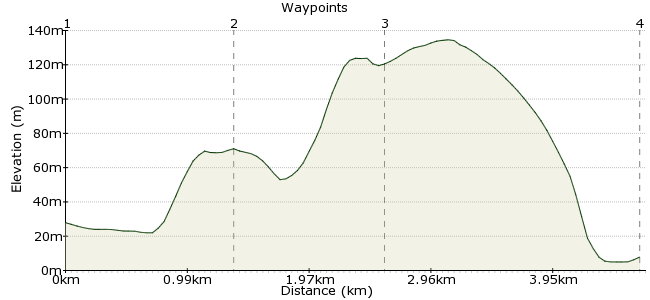
Ascent
92m (301ft)
Descent
112m (367ft)
Max. Elevation
140m (459ft)
Altitude Gain & Loss
204m (668ft)
Start
Ringmer (War Memorial)
End
Lewes Bus Station/Waitrose
Distance
4.70km
(2.92mi)
(2.92mi)
Duration
~1:30h
Difficulty
Leisurely
Ordnance Survey Map
A walk encompassing beautiful South Downs scenery, involving a short, steep climb, followed by a long, gradual climb, and culminating in a steep descent by road. It is only suitable for walkers as two stiles must be crossed.
Ringmer is most easily reached via the No. 28 bus service from Brighton or Lewes which operates half-hourly on Mondays to Saturdays, and hourly on Sundays. There is a wide variety of bus and train services available at Lewes.
Walk Functions
Share
Nearby Walks
Downs and Out
A leisurely, linear walk (countryside) starting in East Sussex, England, about 6.90km (4.29 mi) long, duration: ~2:15h.Two Hemispheres Walk
A moderate, linear walk (low hills and fells (below 600m)) starting in East Sussex, England, about 9.90km (6.15 mi) long, duration: ~3:15h.South Downs Way: Housedean Farm to Pyecombe
A moderate, linear walk (low hills and fells (below 600m)) starting in East Sussex, England, about 11.10km (6.90 mi) long, duration: ~3:30h.Walk Map
- $walk->POI array(0)
Waypoints
OS Grid TQ446123
Start of the walk
OS Grid TQ449110
Start of Week Lane
About 1.32 km (~0.82 miles) from 
OS Grid TQ439105
Left fork, avoiding stile and golf course. Route from here initially uses permissive tracks which soon join another Right of Way.
About 1.14 km (~0.71 miles) from 
 Lewes
LewesOS Grid TQ418103
From Cliffe Hill, drop into Cliffe and over the River Ouse into Lewes.
About 2.10 km (~1.3 miles) from 
