Swinside Fell and Stoneside Hill
A moderate walk (low hills and fells (below 600m)) in national park Lake District in Cumbria, England, about 14.60km (9.07 mi) long with an estimated walking time of about 5:30h. It is unsuitable for families with children, prams & pushchairs, wheelchairs.
Elevation Profile
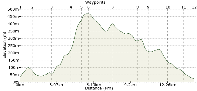
Ascent
457m (1499ft)
Descent
461m (1512ft)
Max. Elevation
470m (1541ft)
Altitude Gain & Loss
918m (3011ft)
Start & End
The Green
Distance
14.60km
(9.07mi)
(9.07mi)
Duration
~5:30h
Difficulty
Moderate
Ordnance Survey Map
A great walk in a quieter corner of the Lakes. No craggy peaks or knife-edge ridges, but the rolling moorland mounds of Swinside Fell are well worth a day's wandering. Enjoy.
Walk Functions
Share
Nearby Walks
Swinside Fell and Black Combe
A moderate, linear walk (low hills and fells (below 600m)) starting in Cumbria, England, about 12.20km (7.58 mi) long, duration: ~5:15h.Cumbrian coast from Millom to Silecroft
A moderate, linear walk (coast) starting in Cumbria, England, about 10.00km (6.21 mi) long, duration: ~2:45h.Black Combe
A moderate, linear walk (low hills and fells (below 600m)) starting in Cumbria, England, about 11.00km (6.84 mi) long, duration: ~4:45h.Walk Map
- $walk->POI array(0)
Waypoints
OS Grid SD178846
Start at The Green, a village just outside the Lake District. There are buses, or Green Road Station is just 15 minutes away.
OS Grid SD167847
Cross the road outside the village and take the road opposite. Just 100m on your right is a footpath heading over the fields to Brockwood Hall. Continue past to the road at Langthwaite Bridge.
About 1.06 km (~0.66 miles) from 
OS Grid SD152846
From Langthwaite Bridge, it's a short road walk through the Whicham Valley to Whicham Mill. There is a short dogleg of footpath at Fox and Goose cottages, which cuts out a bit of the road. At Beckside, head into the Whitecombe Beck valley towards Whicham Mill.
About 1.51 km (~0.94 miles) from 
OS Grid SD149862
It's a great valley walk up towards Whitecombe screes - quiet, hidden and a fantastic backdrop of the Whitecombe Screes.
About 1.54 km (~0.96 miles) from 
OS Grid SD148870
At the mouth of the beck, the path cuts sharply up the hillside on to White Combe.
About 0.83 km (~0.52 miles) from 
OS Grid SD151874
This is the high point of Swinside Fell, a flat, grassy fell. Depending on how energetic you feel, either follow the edge of the plateau around Black Crag, or head across the felltop to Stoneside Hill.
About 0.51 km (~0.32 miles) from 
OS Grid SD145892
Modest in height but proud in view. Many of the southern Lakeland tops can be spied from here, as well as the oft-forgotten Cumbrian coast.
About 1.93 km (~1.2 miles) from 
OS Grid SD164887
Head into the valley between Swinside Fell and Thwaites Fell, where there is a bridleway. Follow this downhill into the Whicham Valley.
About 1.91 km (~1.19 miles) from 
OS Grid SD171881
You will pass the Bronze Age stone circle of Sunkenkirk, interesting if you like that sort of thing (I grew up near Stone Henge so am fairly immune to their charms).
About 0.92 km (~0.57 miles) from 
OS Grid SD173867
A long and winding footpath takes you past Knott Hill and back towards The Green.
About 1.48 km (~0.92 miles) from 
OS Grid SD178854
Drop into Hallthwaites and follow the quiet road round to The Green.
About 1.32 km (~0.82 miles) from 
 The Green again
OS Grid SD179846
The Punchbowl is a good pub in which to wait for your bus or train home...
About 0.86 km (~0.53 miles) from 
