Loggerheads, Cilcain and Moel Famau
A moderate walk (countryside) in Denbighshire, Wales, about 11.40km (7.08 mi) long with an estimated walking time of about 4:15h. It is suitable for families with children, but unsuitable for prams & pushchairs, wheelchairs.
Elevation Profile
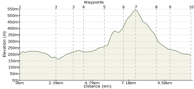
Ascent
382m (1253ft)
Descent
391m (1282ft)
Max. Elevation
550m (1804ft)
Altitude Gain & Loss
773m (2535ft)
Start & End
Loggerheads Country Park
Distance
11.40km
(7.08mi)
(7.08mi)
Duration
~4:15h
Difficulty
Moderate
Ordnance Survey Map
 1Created by driver 16 on 19 Mar 2011
Once again the old faithful Pathfinder Guide No. 32, Walk No.25, 8 miles, 5 hours, although it took me 6 hours after making a couple of mistakes, located between Mold and Ruthin! In Ruthin there is a gaol built as early as 1654 (closed in 1916), which is open to the public. The fee is £3.50 with an audio guide and it takes about an hour to go round. Nantclwyd House is also good, dating 1435-2007, again open to the public from 1st April each year. Guide books (inexpensive) on Loggerheads, Jubilee Tower, Gaol and Nantclwyd House all available. And besides all that, a bit of the Clwydian Way to enjoy!  See photos at www.visitorreview.com/carfreewalks (tried out new camera with 10X optical zoom and 40X digital zoom).
Walk Functions
Share
Nearby Walks
Mold walk - Daniel Owen
A leisurely, circular walk (city/town) starting in Flintshire, Wales, about 3.20km (1.99 mi) long, duration: ~0:45h.Hawarden Park and farm shop
A moderate, circular walk (countryside) starting in Flintshire, Wales, about 10.00km (6.21 mi) long, duration: ~3:00h.Ewloe Castle
A leisurely, circular walk (woodland) starting in Flintshire, Wales, about 3.60km (2.24 mi) long, duration: ~1:15h.Walk Map
- $walk->POI array(0)
Waypoints
OS Grid SJ196629
Visitor Centre/gift shop and cafe. Cross the bridge over the River Alyn, and go left along the path signed 'Leete path and Devil's Gorge'. Right at no.4 post, and take the gap through the wall at no.7 post. (Don't climb steps). See photos at visitorreview.com/carfreewalks. Go through the kissing gate above the kennels, cross the tarred lane and on to the path signed 'Leete path and Cilcain'. Cross the bridge at Devil's Gorge, and continue to reach minor road (waypoint 2).
OS Grid SJ187652
Turn downhill and wind with the lane to cross the narrow bridge; don't take the bridleway, but continue uphill to a sharp right-hand bend. Fork left along the path, keeping left of the fields. Cross some stiles to reach a patch of rowan trees and a gap in the fence on the left. Turn right at the bottom and follow the bridleway to turn right along a lane into the village.
About 2.48 km (~1.54 miles) from 
OS Grid SJ177652
Turn left to pass in front of the White Horse Inn, then pass the church and turn left downhill to waypoint 4.
About 1.03 km (~0.64 miles) from 
OS Grid SJ171648
At a very sharp left bend, turn right up the farm drive, go through the gate and keep to the left side of two long fields to waypoint 5.
About 0.65 km (~0.4 miles) from 
OS Grid SJ158644
Heading down a rough lane, turn right and immediately left on to a bridleway to see the reservoir enclosure, which you pass on the right. Go straight on through open country to the crossroads (waypoint 6).
About 1.40 km (~0.87 miles) from 
OS Grid SJ163633
My 1st mistake! I turned right, but you need to go straight on to waypoint 7.
About 1.18 km (~0.73 miles) from 
OS Grid SJ160626
Built in 1810, the tower collapsed in 1862 after two days of severe gales; see the triangulation pillar. Cross a stile signed 'Loggerheads' and follow signs across a forestry road to a T junction. Here you will see the ford over the stream and waypoint 8.
About 0.72 km (~0.45 miles) from 
OS Grid SJ174628
Turn right down to the ford, then turn left along the forestry road. Follow signs for 'Loggerheads' and waypoint 9.
About 1.39 km (~0.86 miles) from 
OS Grid SJ181624
My 2nd mistake! I turned right instead of left and ended up at Moel Famau car park, which is 2 miles from the Loggerheads complex. Instead, aim for Tan-y-Gelyn to the main road and back to Loggerheads and the end of the walk.
About 0.86 km (~0.53 miles) from 
 End of the walk
OS Grid SJ194629
Hope you enjoyed it as much as I did!
About 1.34 km (~0.83 miles) from 

6 comments... join the discussion!
driver 16
this walk on site since March 2011, 6 years, 1st. negative comment, please read walk description, 8 miles, 5 hours and see Elevation Scale which does show steep ascents and descents, enough said, recently an enterprising lady has opened a snack bar at the summit.
driver 16
Walk has been on site since March 2011 i.e. 6 years, 1st. negative comment, the Gift Shop has a Child's low level walk in Waypoint 1 where they are encouraged to spot things on the way i.e. landmarks, animals, birds, etc., when I loaded the walk up I advised that people with children should follow this guide and make this a circular walk and turn back as in the guide.
SHirley Johnson
Whilst there are many beautiful moments in this walk it is misleadingly presented. There are several sharp gradients uphill and ( especially) downhill and by no stretch of the imagination can it be described as 'leisurely'. Hats off to anyone who manages to get their children/ family round it! As a parent I would say that it is totally unsuitable for children. Maps unintelligible and pointless.
patrikG
No like button on this, though ;)
Cilcain
Cool. Your site looks great, it is a good source and very informative.
Timwoods
Hi Pete, Great first walk for the new website! Not a part of the country I know, but hope to explore one day soon....