Regents Park to Highgate
A leisurely walk (city/town) starting and finishing in City of London, England, about 9.40km (5.84 mi) long with an estimated walking time of about 3:00h. It is suitable for families with children, but unsuitable for prams & pushchairs, wheelchairs.
Elevation Profile
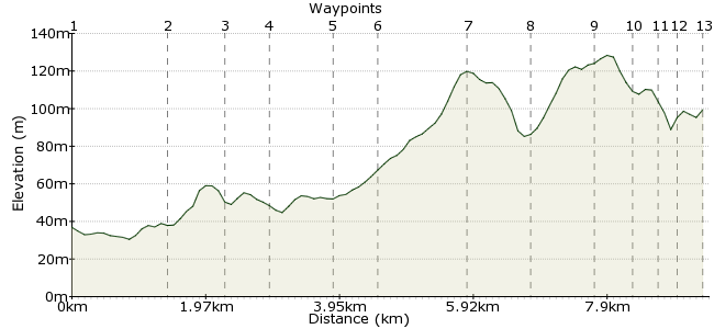
Ascent
126m (413ft)
Descent
62m (203ft)
Max. Elevation
130m (426ft)
Altitude Gain & Loss
188m (616ft)
Start
Paddington
End
N6
Distance
9.40km
(5.84mi)
(5.84mi)
Duration
~3:00h
Difficulty
Leisurely
Ordnance Survey Map
This walk heads from Regent's Park, one of the city's most famous parks, through to Highgate up in north London. Follow the GPX coordinates on this map to explore!
Walk Functions
Share
Nearby Walks
Camden town to Little Venice
A leisurely, linear walk (city/town) starting in City of London, England, about 4.80km (2.98 mi) long, duration: ~1:15h.Along the canals - Camden to Limehouse Basin
A moderate, linear walk (canal) starting in City of London, England, about 9.80km (6.09 mi) long, duration: ~2:45h.Parks, palaces and Portobello Road
A leisurely, linear walk (city/town) starting in City of London, England, about 7.00km (4.35 mi) long, duration: ~2:00h.Walk Map
- $walk->POI array(0)
Waypoints
OS Grid TQ279820
Start at the southern end of Regent's Park. Lots of buses, or you can take the Tube.
OS Grid TQ274833
There's plenty to see as you wander through the park. Finish up by crossing the Grand Union Canal and leaving the park onto Prince Albert Road. Turn right here.
About 1.41 km (~0.88 miles) from 
OS Grid TQ275841
Walk across Primrose Hill from Prince Albert Road, heading north. Upon exiting, head along Primrose Hill Road, then right along Fellows Road.
About 0.79 km (~0.49 miles) from 
OS Grid TQ279845
Turn right into Haverstock Hill, then left into Maitland Park Villas.
About 0.61 km (~0.38 miles) from 
OS Grid TQ277854
At Gospel Oak, turn left onto Fleet Road.
About 0.83 km (~0.52 miles) from 
OS Grid TQ271857
You soon reach Hampstead, one of London's smartest neighbourhoods. Follow signs to the Heath for some more green open space.
About 0.68 km (~0.42 miles) from 
OS Grid TQ269869
Weave through the joggers, coffee drinkers and families on the Heath. Aim for Ken Wood, in the centre, then veer right.
About 1.27 km (~0.79 miles) from 
OS Grid TQ277870
Leave via Fitzroy Park and follow this road away from the heath.
About 0.84 km (~0.52 miles) from 
OS Grid TQ282878
Cross Hampstead Road and go north up North Road. Take the footpath onto Southwood Lane, then a left onto Bloomfield Road. Cross Archway Road at the end.
About 0.95 km (~0.59 miles) from 
OS Grid TQ282883
Enter Highgate Wood, aiming for the Lodge.
About 0.45 km (~0.28 miles) from 
OS Grid TQ285885
Cross Muswell Hill Road to enter Queen's Wood.
About 0.34 km (~0.21 miles) from 
OS Grid TQ287884
Cross the road and continue through the woods.
About 0.27 km (~0.17 miles) from 
 Station
OS Grid TQ285881
Head along Priory Gardens to reach Highgate station.
About 0.32 km (~0.2 miles) from 
