Fremington Edge and Arkengarthdale
A moderate walk (low hills and fells (below 600m)) in national park Yorkshire Dales in North Yorkshire, England, about 13.30km (8.26 mi) long with an estimated walking time of about 4:30h. It is suitable for families with children, but unsuitable for prams & pushchairs, wheelchairs.
Elevation Profile
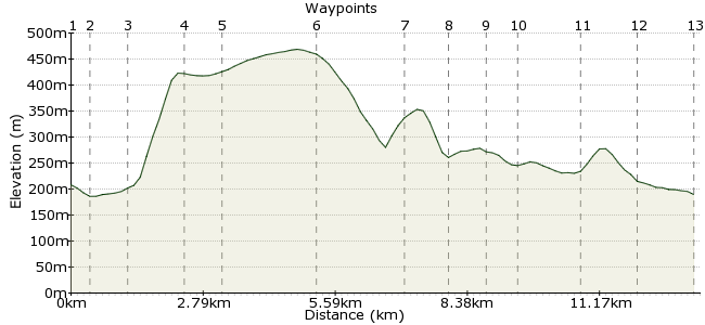
Ascent
285m (935ft)
Descent
304m (997ft)
Max. Elevation
470m (1541ft)
Altitude Gain & Loss
589m (1932ft)
Start & End
Reeth
Distance
13.30km
(8.26mi)
(8.26mi)
Duration
~4:30h
Difficulty
Moderate
Ordnance Survey Map
This walk explores a lesser known corner of the Yorkshire Dales, Arkengarthdale. Starting Reeth in Swaledale, it's a testing climb onto the classic dales escarpment of Fremington Edge. From here, you keep high before dropping down into Langthwaite, which will be familiar to fans of James Herriot programmes - much of the tv series was filmed here. The route concludes by following Arkle Beck along the dale back to Reeth.
Buses to Reeth, but none go up Arkengarthdale, so make sure all party members will complete the route.
Walk Functions
Share
Nearby Walks
The outer reaches of Swaledale
A moderate, linear walk (countryside) starting in North Yorkshire, England, about 15.60km (9.69 mi) long, duration: ~5:00h.Exploring the mines around Grinton
A leisurely, circular walk (low hills and fells (below 600m)) starting in North Yorkshire, England, about 8.30km (5.16 mi) long, duration: ~3:15h.Apedale from Aysgarth
A moderate, circular walk (low hills and fells (below 600m)) starting in North Yorkshire, England, about 19.70km (12.24 mi) long, duration: ~6:45h.Walk Map
- $walk->POI array(0)
Waypoints
OS Grid SE037993
Take the bus to Reeth in Swaledale. Fremington Edge overshadows the town, offering a tempting view of the day ahead.
OS Grid SE041991
Head through the town to the bridge over Arkle Beck. Immediately after crossing, a footpath heads off to your left along the river.
About 0.43 km (~0.27 miles) from 
OS Grid SE039999
Where the path forks, take the right-hand path to Cuckoo Hill and Fremington Edge.
About 0.76 km (~0.47 miles) from 
OS Grid NZ050000
A steep path leads directly up onto the Edge. There is a choice of paths, the right-hand one will give you more time along the Edge, which is the aim of the walk after all.
About 1.03 km (~0.64 miles) from 
OS Grid NZ044006
Once you have reached the path running along the crest of the Edge, head northwest, with Arkengarthdale below.
About 0.82 km (~0.51 miles) from 
OS Grid NZ031021
Continue along the top, enjoying the views into the dale, until Fell End Moor, where you can pick up the bridleway heading down into the dale.
About 1.94 km (~1.21 miles) from 
OS Grid NZ014024
No two ways about it - Booze is a great name for a hamlet. A little further to the pub though.
About 1.80 km (~1.12 miles) from 
OS Grid NZ004024
Continue on to Langthwaite, the largest settlment in Arklegarthdale. It's also where they filmed a lot of 'All Creatures Great and Small'. The Red Lion, which doubled as the Drover's Arms in the programme, is a good option for a pint. www.redlionlangthwaite.co.uk
About 0.90 km (~0.56 miles) from 
OS Grid NZ012020
It's possible to return to Reeth over Calver Hill, but I like to mix up a day's walking with some high and low stuff, so suggest following Arkle Beck along the course of the dale.
About 0.85 km (~0.53 miles) from 
OS Grid NZ017019
Look up to admire this old stone farm building.
About 0.52 km (~0.32 miles) from 
OS Grid NZ029011
Walking back beneath Fremington Edge gives you a different perspective of the feature. You can see more clearly the sharpness with which the rock was cut away as the glacial waters of the last Ice Age melted away.
About 1.39 km (~0.86 miles) from 
OS Grid NZ036004
There's a high road or a low road option - the bridleway running higher up the escarpment. They join just outside a small woodland, good for spotting birds, which love the quiet surroundings of Arkengarthdale.
About 1.01 km (~0.63 miles) from 
 Reeth again
OS Grid SE040992
Back into Reeth for the bus home. Grinton Youth Hostel is a short walk away if you want to explore this area a little longer.
About 1.30 km (~0.81 miles) from 

1 comment... join the discussion!
Maggie
Very clear! thanks!I find the information I want.Will take the walk one day. It is a lively place!