Ben Bhraggie and Big Burn
A moderate walk (low hills and fells (below 600m)) in Highlands, Scotland, about 11.20km (6.96 mi) long with an estimated walking time of about 4:15h. It is suitable for families with children, but unsuitable for prams & pushchairs, wheelchairs.
Elevation Profile
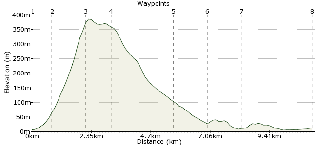
Ascent
368m (1207ft)
Descent
362m (1187ft)
Max. Elevation
390m (1279ft)
Altitude Gain & Loss
730m (2394ft)
Start & End
Golspie - Fountain Road
Distance
11.20km
(6.96mi)
(6.96mi)
Duration
~4:15h
Difficulty
Moderate
Ordnance Survey Map
This is a walk through varied country, including an accessible hill summit with extensive views, woodland, a waterfall, low coastline and a fairytale castle! There are options to shorten the route at several points. Tip ; buy the excellent booklet Golspie Walks (price £1 - 2010) from local outlets, it includes clear maps. Why not string together your own route from these short walk ideas? Golspie is served by several daily trains on the Far North line between Inverness and Wick, also by long distance buses.
Walk Functions
Share
Nearby Walks
Inverness viewpoint - Daviot Wood
A leisurely, circular walk (countryside) starting in Highlands, Scotland, about 4.40km (2.73 mi) long, duration: ~1:15h.Little Assynt to Lochinver
A moderate, linear walk (low hills and fells (below 600m)) starting in Highlands, Scotland, about 11.90km (7.39 mi) long, duration: ~4:00h.Cullen to Portsoy
A moderate, linear walk (coast) starting in Moray, Scotland, about 9.80km (6.09 mi) long, duration: ~2:45h.Walk Map
- $walk->POI array(0)
Waypoints
OS Grid NH831999
The walk to Ben Bhraggie starts from Fountain Road and is clearly signposted from the main road. Pass the fountain, railway bridge and some farm buildings, then take the left hand fork where the track divides (signposted).
OS Grid NC827005
Pass a watertank on the right, go through a gate in the fence straight ahead and walk up the winding forest track. Look out for a path branching off to the right - it is signed for Ben Bhraggie. (Ignore an earlier muddy side path with an arrow pointing right!) Continue up through the wood under power lines, cross two forestry roads, aiming for the distinctive monument on top of the hill.
About 0.72 km (~0.45 miles) from 
OS Grid NC814009
The huge monument commemorates the Duke of Sutherland (1837), infamous in the history of the Highland clearances. A great vantage point with views of the coast and inland hills. Use the free telescope to read the time on the clocktower at Dunrobin Castle! Behind the monument a track heads off northwest.
About 1.36 km (~0.85 miles) from 
OS Grid NC807015
The track bends eastwards. Ignore a shortcut (mountain bike trail) on the right part way down, and continue downhill into the trees. Where the track crosses a forestry road, go straight ahead (path marked with a blue arrow)till you reach a minor tarred road. Turn left along the road, and look for a gate on the right into the wood, marked 'Waterfall' on a small metal sign at ground level.
About 0.97 km (~0.6 miles) from 
OS Grid NC832015
Cross the burn by a bridge and head uphill slightly. There are various alternative path options within the Big Burn woodland, which is rich in wild flowers. Turn off the high level path to view the waterfall, before dropping down to the burn; turn right here for a closer look at the waterfall, then retrace your steps, criss-crossing the burn on five bridges through a shady gorge. After passing under a high railway viaduct you reach a stonemason's yard and the A9.
About 2.50 km (~1.55 miles) from 
OS Grid NC840005
Cross the A9 with care (there is a pavement) and walk back towards Golspie. If time allows, the walk can be extended by turning left into Duke Street(opposite the church)and crossing a bridge next to the ford. A path hugs the low coastline over grass, leading to Dunrobin Castle with its fairytale turrets. The woods below the castle display stunning drifts of bluebells in early summer and snowdrops in early spring.
About 1.28 km (~0.8 miles) from 
OS Grid NC852007
There are various return options from here. (a) Retrace your steps back to Golspie, (b) continue northeast along the coast path to Brora (on the rail and bus route); at low tide it is possible to walk part of the way on the sandy beach, where seals may often be seen, or (c) follow a signed track up to the castle and down the main drive to Dunrobin Castle station. Note this is a summer request stop only - check the timetable and flag the train down as soon as it comes round the bend!
About 1.24 km (~0.77 miles) from 
 Golspie rail station
OS Grid NH825997
Walk along the A9 through the town to the station - unless taking the option to arrive by train from Brora or Dunrobin Castle!
About 2.89 km (~1.8 miles) from 

1 comment... join the discussion!
maryw
We repeated this walk on 29th Feb 2012 - this time enjoying massed drifts of snowdrops in the woods below Dunrobin Castle and in the gardens (free entry to gardens in winter when the castle is closed). We approached Dunrobin Castle by walking along the coast from Brora (approx 4 miles), where we alighted bright and early from the northbound train. As it was low tide, we were able to walk on firm sandy beach for the first part (there is also a higher route over grass al the way). Saw a dozen or so seals on the rocks and on the beach! Great views of the castle coming from this direction.