Ben Cleuch and Ochils Walk
A leisurely walk (mountain (above 600m)) in Clackmannanshire, Scotland, about 8.80km (5.47 mi) long with an estimated walking time of about 4:15h. It is suitable for families with children, but unsuitable for prams & pushchairs, wheelchairs.
Elevation Profile
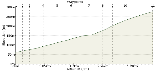
Ascent
647m (2122ft)
Descent
673m (2208ft)
Max. Elevation
280m (918ft)
Altitude Gain & Loss
1320m (4330ft)
Start & End
Tillicoultry
Distance
8.80km
(5.47mi)
(5.47mi)
Duration
~4:15h
Difficulty
Leisurely
Ordnance Survey Map
 Created by pentland on 17 Aug 2011
A moderate to strenuous walk to gain the plateau area of the high Ochils. Depending on weather conditions, you may be blessed with extensive views over Stirling, the River Forth and The Forth Valley. Whether suitable for families depends on weather conditions, and the age, fitness and temperement of the children. Map and compass recommended at all times, especially in poor weather.
The nearest station is in Stirling; regular buses from here to Tillicoultry.
Walk Functions
Share
Nearby Walks
The Ochil Hills - Ben Cleuch and Bengengie Hill
A moderate, linear walk (mountain (above 600m)) starting in Clackmannanshire, Scotland, about 14.80km (9.20 mi) long, duration: ~6:15h.Ben Ledi from Callander
A moderate, circular walk (mountain (above 600m)) starting in Stirlingshire, Scotland, about 17.30km (10.75 mi) long, duration: ~7:15h.Around the sights of Callander
A moderate, circular walk (low hills and fells (below 600m)) starting in Stirlingshire, Scotland, about 13.50km (8.39 mi) long, duration: ~4:45h.Walk Map
- $walk->POI array(0)
Waypoints
OS Grid NS913974
Take the bus to Tillicoultry. A path signposted to Mill Glen leads upwards past waterfalls and over bridges to lead to the hillside route up into The Ochils.
OS Grid NS911979
At waypoint 2, leave the paths leading up The Law and Gannel Burn to head westerly to the north of the quarry. Join the track and head north.
About 0.45 km (~0.28 miles) from 
OS Grid NS909982
At waypoint 3 the path continues northerly, but here you should follow the path/track that goes left or westerly up the hillside. You'll then gain access to the upper slopes; swing right or northerly to gain the 395m spot height.
About 0.36 km (~0.22 miles) from 
OS Grid NS902987
Keep heading up the steep slope to Wood Hill.
About 0.90 km (~0.56 miles) from 
OS Grid NS897993
Once on the ridge, keep heading along it.
About 0.86 km (~0.53 miles) from 
OS Grid NN893001
The path takes you to Ben Ever, a near-neighbour of Ben Cleuch.
About 0.83 km (~0.52 miles) from 
OS Grid NN902006
Follow the edge of the valley around to Ben Cleuch.
About 1.04 km (~0.65 miles) from 
OS Grid NN909002
Head away from the summit along a south-easterly bearing.
About 0.81 km (~0.5 miles) from 
OS Grid NS910996
Drop down to The Law; you can pick up the path you started on from here.
About 0.55 km (~0.34 miles) from 
OS Grid NS910989
It's a steep descent; take care.
About 0.75 km (~0.47 miles) from 
 Tillicoultry
OS Grid NS914972
Finish up in Tillicoultry again for the bus home.
About 1.75 km (~1.09 miles) from 
