Purbeck Coast
A moderate walk (coast) starting and finishing in Dorset, England, about 12.10km (7.52 mi) long with an estimated walking time of about 3:45h. It is suitable for families with children, but unsuitable for prams & pushchairs, wheelchairs.
Elevation Profile
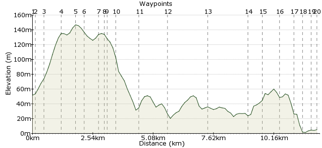
Ascent
133m (436ft)
Descent
179m (587ft)
Max. Elevation
150m (492ft)
Altitude Gain & Loss
312m (1023ft)
Start
Harmans Cross Station
End
Swanage, Dorset, England
Distance
12.10km
(7.52mi)
(7.52mi)
Duration
~3:45h
Difficulty
Moderate
Ordnance Survey Map
A lovely walk along the Purbeck coast which can be circular using the bus / steam railway. Reasonably gentle hills, and good underfoot along the cliff tops with some steep sections.
Walk Functions
Share
Nearby Walks
Corfe Castle to Studland Bay
A moderate, linear walk (low hills and fells (below 600m)) starting in Dorset, England, about 19.50km (12.12 mi) long, duration: ~6:00h.Townsend nature reserve to Swanage via Durlston
A leisurely, circular walk (coast) starting in Dorset, England, about 2.70km (1.68 mi) long, duration: ~0:45h.Around the Isle of Purbeck - Swanage to Worth Matravers
A moderate, circular walk (coast) starting in Dorset, England, about 19.20km (11.93 mi) long, duration: ~6:00h.Walk Map
- $walk->POI array(0)
Waypoints
OS Grid SY982800
Starting point is Harman's Cross station on the Swanage Railway - you can get here by train or on the Number 40 bus from Swanage, Wareham and Poole (run by Wilts and Dorset).
OS Grid SY983799
Exit the station (from either platform) and turn right up the hill, following the road.
About 0.10 km (~0.06 miles) from 
OS Grid SY983796
Continue following the road, past various campsites you could choose to stay at.
About 0.37 km (~0.23 miles) from 
OS Grid SY982788
At the end of the road, turn left and pick up the path just past the cottages on the right - it is signposted. Head up across the fields.
About 0.79 km (~0.49 miles) from 
OS Grid SY982783
Cross the road and continue on the path.
About 0.55 km (~0.34 miles) from 
OS Grid SY982779
At the path junction turn left and head along the footpath by the wall in the direction of the buildings you can see.
About 0.39 km (~0.24 miles) from 
OS Grid SY977777
Cross farm track on a stile and then another stile onto the road - follow this down into the village.
About 0.49 km (~0.3 miles) from 
OS Grid SY975777
The Square and Compass - great pub with good cider and perry and does some nice food. A great spot to stop for some lunch.
About 0.22 km (~0.14 miles) from 
OS Grid SY976777
Double back along the road until a gate on your right with the National Trust sign 'East Man'. Follow path along the wall.
About 0.05 km (~0.03 miles) from 
OS Grid SY978774
At the path junction (clearly marked by a wooden sign) turn left and follow the path to Seacome.
About 0.36 km (~0.22 miles) from 
OS Grid SY984767
Upon reaching Seacome, follow the coastal path in a easterly direction (left!) towards Dancing Ledge. There are waymarking stones roughly every mile.
About 0.88 km (~0.55 miles) from 
OS Grid SY996769
A nice place for a picnic or to admire the view. Keep following the path along the cliff top.
About 1.26 km (~0.78 miles) from 
OS Grid SZ012768
Pass some light towers heading out to sea - if the weather is bad you could cut the walk short by heading inland from here.
About 1.57 km (~0.98 miles) from 
OS Grid SZ029769
Lighthouse with a lovely view. Follow the path round to the right (seaward) side of the lighthouse. There is a dip and some steep steps up.
About 1.69 km (~1.05 miles) from 
OS Grid SZ034772
At this point the coastal path was closed and there is a signed diversion up to the car park and back down again.
In the carpark - exit the path and turn right, follow the road to the left and pick up the coastal path signs again.
About 0.59 km (~0.37 miles) from 
OS Grid SZ032779
Follow the coastal path signs on lamposts etc along the roads.
About 0.76 km (~0.47 miles) from 
OS Grid SZ035783
Lovely view here over Swanage as you drop down to the sea front, where many places offer refershments.
About 0.53 km (~0.33 miles) from 
OS Grid SZ033787
Lovely but busy harbour - follow the harbour front round until you reach the cinema.
About 0.38 km (~0.24 miles) from 
OS Grid SZ031788
The Mowlem Complex - at this point leave the coast and head inland on the road to the station.
About 0.28 km (~0.17 miles) from 
 Swanage Station
OS Grid SZ028789
Walk end - Swanage station - from here you can get the bus 40 or the steam railway back to where you came from. Alternatively get bus number 50 along to Bournemouth.
About 0.28 km (~0.17 miles) from 

3 comments... join the discussion!
Tim Woods
Thanks Andrew, we'll correct that asap.
Andrew
We took a short cut across the peninsular at the end, but even so the OS app on my phone reckoned the walk was 9.2 miles. Maybe half a mile could be explained by the diversion at step 6. I wonder how the distances were calculated?
Andrew
We think there is a mistake at point 6. It should say turn right, not left.