Inverness viewpoint - Daviot Wood
A leisurely walk (countryside) in Highlands, Scotland, about 4.40km (2.73 mi) long with an estimated walking time of about 1:15h. It is suitable for families with children, prams & pushchairs, wheelchairs.
Elevation Profile
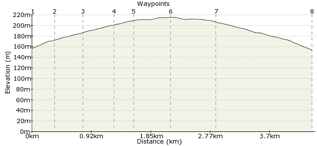
Ascent
58m (190ft)
Descent
61m (200ft)
Max. Elevation
220m (721ft)
Altitude Gain & Loss
119m (390ft)
Start & End
Milton of Leys, Inverness
Distance
4.40km
(2.73mi)
(2.73mi)
Duration
~1:15h
Difficulty
Leisurely
Ordnance Survey Map
A fairly short walk with a gentle gradient - the reward being extensive views out across the Moray Firth to the Black Isle and layers of hills beyond. Easily accessed by a city bus route from Inverness to the new housing development of Milton of Leys (journey time ca 25 mins). The walk quickly leaves the built-up area behind, leading across open heath into woodland. Gravel/dirt tracks are suitable for robust buggies. There is potential to extend the walk along a network of forest tracks in Daviot Wood before returning. Maps of the wood are mounted on boards at intervals.
Â
Walk Functions
Share
Nearby Walks
Loch Ness viewpoint - Meall Fuar Mhonaidh
A strenuous, circular walk (mountain (above 600m)) starting in Highlands, Scotland, about 20.70km (12.86 mi) long, duration: ~8:00h.The Falls of Foyers
A leisurely, circular walk (woodland) starting in Highlands, Scotland, about 9.40km (5.84 mi) long, duration: ~3:30h.Boat of Garten to Glenmore
A moderate, linear walk (woodland) starting in Highlands, Scotland, about 18.90km (11.74 mi) long, duration: ~6:00h.Walk Map
- $walk->POI array(0)
Waypoints
OS Grid NH693419
The bus journey from Inverness city centre eastwards to Milton of Leys takes around 25 minutes. Ask for the stop just before the new primary school. Cross the road opposite the bus shelter and turn right into Redwood Avenue. Almost immediately, turn left past staggered metal barriers onto a path leading between the burn on your left and the backs of houses on your right. This path joins a tarred road by an electricity sub-station.
OS Grid NH696418
Turn left onto the road, then immediately left again where the path continues between trees, soon emerging into the cul-de-sac of Castleton Village. Turn right and walk straight up this road to where it ends at a barred gate leading into the woods.
About 0.31 km (~0.19 miles) from 
OS Grid NH699417
Passing through the gate, continue up the track until a fork by a pond is reached. Do not continue straight on (this leads only to the very busy A9!) - take the righthand path, which begins to climb gently uphill, taking you into an open heathland of gorse and heather.
About 0.36 km (~0.22 miles) from 
OS Grid NH702413
Keep a lookout on the right hand side, as the 'viewpoint' (marked on the Forestry Commission display map near the entrance gate) is in fact simply a pile of hard-packed gravel! But worth climbing on to to admire the extensive views across the Moray Firth to Inverness, the Black Isle and hills beyond. The path continues up to the fringe of the forest.
About 0.42 km (~0.26 miles) from 
OS Grid NH705412
Turn left at the first track junction (there is another useful display map board at this point). At the next junction, either route leads to a car park and clearing bordering the A9.
About 0.27 km (~0.17 miles) from 
OS Grid NH710414
There are picnic tables and a small tourist information centre with toilets (closed in winter months). A free map of the forest trails can be obtained from the centre (when it's open), enabling you to devise a longer woodland circuit if you wish.
About 0.52 km (~0.32 miles) from 
OS Grid NH704411
Follow the sign to the right,back to the viewpoint and down to the entrance gate. Once on the road, retrace your steps back to the main road and head for the bus shelter downhill on the left. Milton of Leys, as a new housing development, is sadly devoid of refreshment options at this point!
About 0.60 km (~0.37 miles) from 
 Bus shelter
OS Grid NH692419
Wait here for the return bus to Inverness.
About 1.43 km (~0.89 miles) from 
