Munro's big bags
A hard walk (mountain (above 600m)) in Highlands, Scotland, about 32.50km (20.19 mi) long with an estimated walking time of about 13:45h (1 overnight stay). It is unsuitable for families with children, prams & pushchairs, wheelchairs.
Elevation Profile
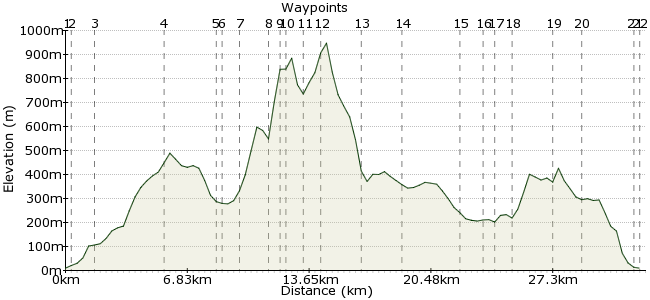
Ascent
1447m (4747ft)
Descent
1447m (4747ft)
Max. Elevation
950m (3116ft)
Altitude Gain & Loss
2894m (9494ft)
Start & End
Strathcarron Railway Station
Distance
32.50km
(20.19mi)
(20.19mi)
Duration
~13:45h
Difficulty
Hard
Ordnance Survey Map
 Car Free Walks TeamCreated by GaryShipp on 04 Oct 2011
This is one very full day walk, or two slightly more sedentary days out. If the later, then the Bearnais Bothy offers a delightful stop over point and one of our most comfortable bothy nights ever. If the former, then be warned of the perils of a late return and missing the final train of the day.
The walk itself starts and finished over less testing ground, but picks up in the middle third with some hefty ascending and choice route finding.
All in all, a proper Scottish adventure.
Walk Functions
Share
Nearby Walks
Fuar Tholl, Sgorr Ruadh and Beinn Liath Mhor
A moderate, circular walk (mountain (above 600m)) starting in Highland, Scotland, about 16.00km (9.94 mi) long, duration: ~8:00h.South Torridon Passes
A moderate, linear walk (low hills and fells (below 600m)) starting in Highlands, Scotland, about 12.70km (7.89 mi) long, duration: ~5:00h.Kinlochewe to Lochan Fada
A strenuous, circular walk (riverside) starting in Highlands, Scotland, about 21.50km (13.36 mi) long, duration: ~7:00h.Walk Map
- $walk->POI array(0)
Waypoints
OS Grid NG942421
Strathcarron station, marked on some OS maps as Srath Carron.
OS Grid NG942417
Find the path leaving the village
About 0.39 km (~0.24 miles) from 
OS Grid NG956416
Take the left hand path
About 1.45 km (~0.9 miles) from 
OS Grid NG993416
Follow the path through the saddle and past the small lochon.
About 3.69 km (~2.29 miles) from 
OS Grid NH020430
A delightful little bothy to rest up in. Warm, peaceful and relatively unbusy (according to the visitors book at least!)
About 2.99 km (~1.86 miles) from 
OS Grid NH022429
Choose your spot carefully to cross and then head across the open hillside aiming for saddle between Beinn Tharsuinn and Bidein a Choire Sheasgaich
About 0.20 km (~0.12 miles) from 
OS Grid NH033425
Once you cross the footpath going NE/SW, contour round the hillside, trying not to lose height or your footwear
About 1.20 km (~0.75 miles) from 
OS Grid NH046423
From here the north side of Bidein a Choire Sheasgaich falls towards you in an impressive two-tier buttress. The route to the top can be by an by interesting Grade 3 scramble, or a more leisurely amble.
About 1.33 km (~0.83 miles) from 
OS Grid NH048417
Stunning views across to Torrindon in the NW.
About 0.65 km (~0.4 miles) from 
OS Grid NH048412
Take a well earned break and soak up the vista.
About 0.46 km (~0.29 miles) from 
OS Grid NH055406
Follow the ridge line down and then back up to Lurg Mhor
About 0.95 km (~0.59 miles) from 
OS Grid NH064404
Height point of this walk.
About 0.94 km (~0.58 miles) from 
OS Grid NH069382
Gain the track and turn westwards.
About 2.28 km (~1.42 miles) from 
OS Grid NH050392
Continue along the wide track past the Loch.
About 2.18 km (~1.35 miles) from 
OS Grid NH017392
Take the turning towards the buildings of Bendronaig Lodge.
About 3.28 km (~2.04 miles) from 
OS Grid NH006387
Easy walking here as tiredness creeps in.
About 1.17 km (~0.73 miles) from 
OS Grid NH002382
Continue along the wide track.
About 0.65 km (~0.4 miles) from 
OS Grid NG993385
Keep an eye out for this path junction turning off to your right.
About 0.92 km (~0.57 miles) from 
OS Grid NG972389
Route finding should be easy here unless snow is on the ground.
About 2.16 km (~1.34 miles) from 
OS Grid NG956394
Not far to go now and mostly downhill!
About 1.69 km (~1.05 miles) from 
OS Grid NG941416
Back where you set out from earlier in the day (or yesterday if you took a more leisurely pace!).
About 2.61 km (~1.62 miles) from 
 Finish of the walk
OS Grid NG941421
Back at the station. The hotel next door has a friendly bar, not always open, whilst the nearby post office and shop has plentiful calories available.
About 0.51 km (~0.32 miles) from 
