Dorset wanderings - Yetminster to Thornford
A leisurely walk (countryside) in Dorset, England, about 5.00km (3.11 mi) long with an estimated walking time of about 1:30h. It is suitable for families with children, but unsuitable for prams & pushchairs, wheelchairs.
Elevation Profile
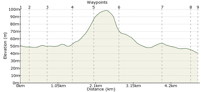
Ascent
40m (131ft)
Descent
50m (164ft)
Max. Elevation
100m (328ft)
Altitude Gain & Loss
90m (295ft)
Start & End
Yetminster
Distance
5.00km
(3.11mi)
(3.11mi)
Duration
~1:30h
Difficulty
Leisurely
Ordnance Survey Map
This walk weaves through the countryside between Yetminster and Thornford, two stops on the Heart of Wessex train line. The beauty is in the walking here - making the most of the many footpaths that weave across our green and pleasant land. The pub in Thornford is worth a visit, but time your walk to get there at lunchtime or the evening - it's not open all day.
Walk kindly sponsored by

Walk Functions
Share
Nearby Walks
In the heart of Thomas Hardy's Dorset
A moderate, circular walk (countryside) starting in Dorset, England, about 14.40km (8.95 mi) long, duration: ~4:45h.Around Maiden Newton
A leisurely, circular walk (countryside) starting in Dorset, England, about 6.70km (4.16 mi) long, duration: ~2:00h.Five village circular walk starting at Barrington
A moderate, circular walk (countryside) starting in Somerset, England, about 11.90km (7.39 mi) long, duration: ~3:30h.Walk Map
- $walk->POI array(0)
Waypoints
OS Grid ST596108
Take the train to Yetminster station.
OS Grid ST599107
Up the steps, turn left to cross the railway bridge. In the village, take the footpath that heads through a small group of houses (not the overgrown one straight ahead).
About 0.25 km (~0.16 miles) from 
OS Grid ST603108
The route then crosses farmland. This route is part of the Macmillan Way: www.macmillanway.org
About 0.47 km (~0.29 miles) from 
OS Grid ST609112
There are a couple of fences to navigate, including an electric one - how did that happen on a footpath? But it is low-hanging and should be easy enough to get over.
About 0.66 km (~0.41 miles) from 
OS Grid ST613115
At Knighton, turn left to face a steep hill - the next footpath is just a few metres ahead (before you go down the hill).
About 0.58 km (~0.36 miles) from 
OS Grid ST609120
The path skirts beneath a patch of woodland on Knighton Hill.
About 0.62 km (~0.39 miles) from 
OS Grid ST601129
More farmland to cross to reach Thornford. There's a shop in the village and a pub, the King's Arms, but check opening times to avoid a thirsty disappointment: www.kingsarmsthornford.co.uk
About 1.17 km (~0.73 miles) from 
OS Grid ST594126
Walk along the road to the station - there's a footpath to avoid having to walk on the road itself. Good work, Dorset Council.
About 0.78 km (~0.48 miles) from 
 Thornford Station
OS Grid ST593125
To the station for the train home.
About 0.18 km (~0.11 miles) from 

1 comment... join the discussion!
Blanche Alexander
The White Hart is a beautiful 16th century thatched free-house with loads of character. Specialising in serving locally sourced Craft Ales and West Country ciders - all from within 20 miles of Yetminster– along with a great selection of other drinks, and hearty pub fare. Open 7 days a week. We welcome walking groups of all sizes. Give us a call to bookl! 01935 872338 www.YetminsterWhiteHart.pub