Great Shunner Fell
A moderate walk (mountain (above 600m)) in national park Yorkshire Dales starting and finishing in North Yorkshire, England, about 15.00km (9.32 mi) long with an estimated walking time of about 5:30h. It is unsuitable for families with children, prams & pushchairs, wheelchairs.
Elevation Profile
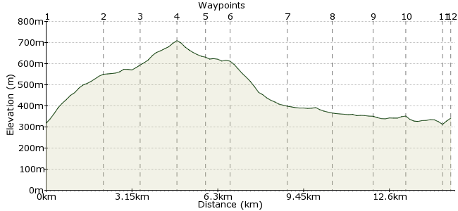
Ascent
427m (1400ft)
Descent
403m (1322ft)
Max. Elevation
710m (2329ft)
Altitude Gain & Loss
830m (2722ft)
Start
Thwaite
End
Keld, Richmond, North Yorkshire, England
Distance
15.00km
(9.32mi)
(9.32mi)
Duration
~5:30h
Difficulty
Moderate
Ordnance Survey Map
Way down the end of Swaledale is Great Shunner Fell. It's a popular hill, accessible from either Swaledale or Wensleydale. The ground can get boggy - it's on the watershed of both dales, feeding the rivers that charge through them - but it's a fantastic little corner of the Dales.
Keld and Thwaite, the nearby villages, are accessible via the Dales & District buses, but note the last bus leaves Keld at about 3pm, and there are no buses on Bank Holidays or Sunday outside of the summer months. Better to make an overnight trip of it and stay at the Tan Hill Inn, about 4 km north of Keld: www.tanhillinn.co.uk. The bunk room is a cheap option and includes a full English breakfast the next day. Alternatively book a room at Keld Lodge in the village: www.keldlodge.com
Walk Functions
Share
Nearby Walks
A Wensleydale walk
A moderate, circular walk (low hills and fells (below 600m)) starting in North Yorkshire, England, about 14.40km (8.95 mi) long, duration: ~5:15h.Raydale and Semer Water
A moderate, circular walk (countryside) starting in North Yorkshire, England, about 14.70km (9.13 mi) long, duration: ~5:15h.Garsdale to Kirkby Stephen via High Seat
A strenuous, linear walk (mountain (above 600m)) starting in Cumbria, England, about 21.90km (13.61 mi) long, duration: ~7:45h.Walk Map
- $walk->POI array(0)
Waypoints
OS Grid SD889983
From the village, follow the path up to Great Shunner Fell. It's a well marked trail, should be easy to find - look for the track off to the left as you leave the village heading north. It's also the Pennine Way, so well signposted.
OS Grid SD868988
Nothing like a steep climb to start the day. There's a steady ascent right from the village to shake off the cobwebs. Why are they called cobwebs?
About 2.12 km (~1.32 miles) from 
OS Grid SD855983
the ground levels off a little above Thwaite Beck, before the final push to the summit.
About 1.32 km (~0.82 miles) from 
OS Grid SD848972
The top! 716m, making it one of the highest in the Dales.
About 1.26 km (~0.78 miles) from 
OS Grid SD839975
Compass at the ready...leave the security of the Pennine Way and bear west-north-west across the flattish ground to Knoutberry Currack.
About 0.99 km (~0.62 miles) from 
OS Grid SD832981
No paths around here, so a case of judging your distance to get here - about 2km from the summit of Great Shunner Fell. Your target is the dryer ground just beyond Wavery Gill.
About 0.93 km (~0.58 miles) from 
OS Grid SD845996
Follow the gill northwards into Great Sled Dale. As you reach the dale bottom, pick up the track on the western side of the gill.
About 1.96 km (~1.22 miles) from 
OS Grid NY856008
The track crosses over the beck a few times before reaching a footpath at Stone House.
About 1.67 km (~1.04 miles) from 
OS Grid NY870013
The path leads to Hoggarths, where you meet the road for the final stretch. Quiet country roads so few traffic worries.
About 1.47 km (~0.91 miles) from 
OS Grid NY881016
It's worth crossing to the path north of the River Swale for the last stretch. Pause at Wain Wath Force for a final breather.
About 1.15 km (~0.71 miles) from 
OS Grid NY893010
At Stonesdale, take the path crossing the River Swale to reach Keld.
About 1.38 km (~0.86 miles) from 
 To Keld
OS Grid NY891009
Finish at Keld, and enjoy a pint and a meal at Keld Lodge, a former Youth Hostel in the village which also does rooms. Well earned after completing one of the more challenging Dales' walks. The Tan Hill in is about an hour's walk to the north if that's your preference.
About 0.29 km (~0.18 miles) from 

2 comments... join the discussion!
Timwoods
Hi Paul, many thanks for the update! I did the walk a few years ago and don't think Keld Lodge was a pub then. Have updated the walk with your details.
Paul C
There will also be buses to Swaledale on Sundays and Bank Holidays between May and September 2012, including a link from Ribblehead Station on the Leeds-Settle-Carlisle line. Details will be available on the DalesBus website at www.dalesbus.org shortly. Note also that the Tan Hill Inn is actually about four miles north of Keld village - food, drink and accommodation is however available in Keld at Keld Lodge.