The Campsie Fells above Strathblane
A moderate walk (low hills and fells (below 600m)) starting and finishing in Stirlingshire, Scotland, about 13.40km (8.33 mi) long with an estimated walking time of about 5:30h. It is unsuitable for families with children, prams & pushchairs, wheelchairs.
Elevation Profile
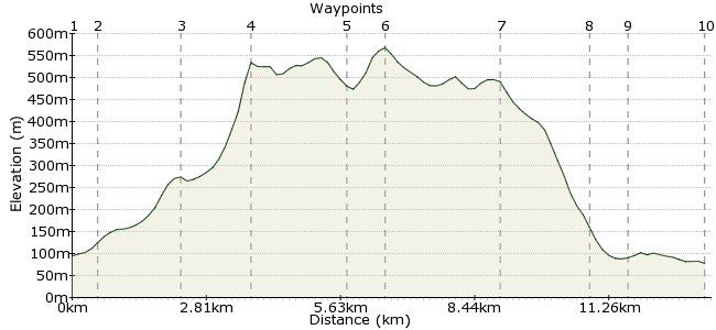
Ascent
539m (1768ft)
Descent
556m (1824ft)
Max. Elevation
570m (1870ft)
Altitude Gain & Loss
1095m (3592ft)
Start
Killearn
End
Strathblane, Glasgow, Lanarkshire, Scotland
Distance
13.40km
(8.33mi)
(8.33mi)
Duration
~5:30h
Difficulty
Moderate
Ordnance Survey Map
The Campsie Fells make for a great day trip from Glasgow. Regular buses run to Killearn and Strathblane, where this walk starts and finishes, and once you have negotiated the steep flanks of the fells, you can wander for miles on the plateau.
Walk Functions
Share
Nearby Walks
The Campsie Fells from Lennoxtown
A moderate, circular walk (low hills and fells (below 600m)) starting in East Dunbartonshire, Scotland, about 11.00km (6.84 mi) long, duration: ~4:30h.Kilpatrick to Balloch
A moderate, linear walk (low hills and fells (below 600m)) starting in Dunbartonshire, Scotland, about 16.70km (10.38 mi) long, duration: ~5:45h.The Kilpatrick Hills: Loch Humphrey and Duncolm
A moderate, circular walk (low hills and fells (below 600m)) starting in City of Glasgow, Scotland, about 15.00km (9.32 mi) long, duration: ~5:30h.Walk Map
- $walk->POI array(0)
Waypoints
OS Grid NS525857
Take the bus to Killearn. Regular buses from Glasgow.
OS Grid NS531858
Follow Ibert Road to Ibert Lodge, then follow the track through Kirkhouse Wood.
About 0.60 km (~0.37 miles) from 
OS Grid NS542844
Upon leaving the wood, head up the slopes to the track near Machar Burn.
About 1.73 km (~1.07 miles) from 
OS Grid NS553836
It's a steep ascent up to Garloch Hill. There's a few little craggy bits near the summit, but nothing unavoidable.
About 1.39 km (~0.86 miles) from 
OS Grid NS573843
Follow the northern edge of the Campsie Fells as it weaves in and out. The views north look over to the Trossachs, one of my favourite walking areas of Scotland (hint: head here afterwards, not back to Glasgow!)
About 2.09 km (~1.3 miles) from 
OS Grid NS569837
You can follow the northern edge and then drop down to Lennoxtown, which also has buses back to Glasgow. But if your inner demons demand you bag peaks, head to the Earl's Seat, the high point of the Campsie Fells and a Marilyn. It has a trig point, useful for navigation in bad weather.
About 0.69 km (~0.43 miles) from 
OS Grid NS572814
A good way down is via Drumbreck, which overlooks Fin Glen.
About 2.32 km (~1.44 miles) from 
OS Grid NS576796
Head south off the hill to pick up the track.
About 1.83 km (~1.14 miles) from 
OS Grid NS579789
No need to walk back along the road; cross over and follow the track back to Strathblane.
About 0.78 km (~0.48 miles) from 
 Strathblane
OS Grid NS562792
Finish at Strathblane, on the same bus route as Killearn. The Kirkhouse Inn is the place for a post-walk drink.
About 1.69 km (~1.05 miles) from 
