A moorland adventure
A strenuous walk (mountain (above 600m)) in national park Dartmoor in Devon, England, about 27.10km (16.84 mi) long with an estimated walking time of about 9:30h (1 overnight stay). It is unsuitable for families with children, prams & pushchairs, wheelchairs.
Elevation Profile
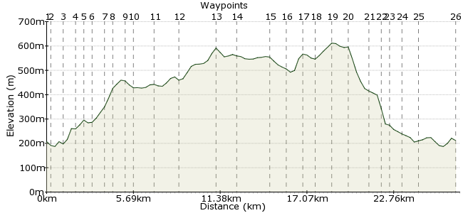
Ascent
588m (1929ft)
Descent
583m (1912ft)
Max. Elevation
620m (2034ft)
Altitude Gain & Loss
1171m (3841ft)
Start & End
Okehampton Station
Distance
27.10km
(16.84mi)
(16.84mi)
Duration
~9:30h
Difficulty
Strenuous
Ordnance Survey Map
 Car Free Walks TeamCreated by GaryShipp on 22 Jan 2012
This route is a circuitous way to the highest summit of the moor, taking in some of the wilder places and viewpoints on the way.
Walk Functions
Share
Nearby Walks
Dartmoor North to South
A hard, linear walk (low hills and fells (below 600m)) starting in Devon, England, about 42.00km (26.10 mi) long, duration: ~13:45h.Cawsand and Little Hound Tor
A leisurely, circular walk (low hills and fells (below 600m)) starting in Devon, England, about 10.30km (6.40 mi) long, duration: ~3:45h.Kitty Tor and Great Links Tor
A moderate, linear walk (low hills and fells (below 600m)) starting in Devon, England, about 11.70km (7.27 mi) long, duration: ~4:15h.Walk Map
- $walk->POI array(0)
Waypoints
OS Grid SX591944
Services run from Exeter St Davids on summer Sundays
OS Grid SX592945
Head for the corner of the car park where you'll find a gate through to some steps. Turn right on the track and head through Tramlines Wood.
About 0.07 km (~0.04 miles) from 
OS Grid SX602947
At the river, turn right. Go under the railway bridge, and then the considerably less aesthetic road bridge and follow the western bank of the East Okement River.
About 1.05 km (~0.65 miles) from 
OS Grid SX606941
Beautiful wooded river valley known in this part of the world as a 'cleave'.
About 0.72 km (~0.45 miles) from 
OS Grid SX607934
Cross over the river here.
About 0.69 km (~0.43 miles) from 
OS Grid SX608936
Whilst these are hills, rather than mountains, there are still plenty of slopes to get the pulse racing.
About 0.25 km (~0.16 miles) from 
OS Grid SX610927
Cross the wide track and head south east to the beckoning rocky ridge
About 0.91 km (~0.57 miles) from 
OS Grid SX615924
Scattered and shattered rocks abound. Keep to the high point for atmospheric views in all directions.
About 0.56 km (~0.35 miles) from 
OS Grid SX613919
As always, one can only marvel at the work that went in to building this.
About 0.56 km (~0.35 miles) from 
OS Grid SX610913
Join the path again and head south to the imposing summit of Oke Tor.
About 0.70 km (~0.43 miles) from 
OS Grid SX611899
Military use of the moor is evident here. Look out for the red range flag indicating live firing is going on in the area, in which case you'll need to make a plan B for your route.
About 1.32 km (~0.82 miles) from 
OS Grid SX613886
Depending on recent rain fall, this could be a quick splash across, or something requiring a little more caution.
About 1.40 km (~0.87 miles) from 
OS Grid SX615861
Looking south you'll trully experience the feeling of wilderness that Dartmoor can conjure.
About 2.49 km (~1.55 miles) from 
OS Grid SX601858
For full background to this place visit http://www.legendarydartmoor.co.uk/cranmere_pool.htm
About 1.43 km (~0.89 miles) from 
OS Grid SX601877
After your recent bog hopping, you might welcome the respite of this track. Yet it still seems terribly out of place in this otherwise wild area.
About 1.92 km (~1.19 miles) from 
OS Grid SX598887
Turn left and head along the path.
About 1.02 km (~0.63 miles) from 
OS Grid SX587887
Turn left at the junction.
About 1.04 km (~0.65 miles) from 
OS Grid SX585881
For more info http://www.richkni.co.uk/dartmoor/dinger.htm
About 0.72 km (~0.45 miles) from 
OS Grid SX579891
Dartmoor's high point at a heady 621m.
About 1.18 km (~0.73 miles) from 
OS Grid SX580902
The slightly lower partner to High Willhays, but a little more presence as a 'proper' Dartmoor Tor.
About 1.08 km (~0.67 miles) from 
OS Grid SX567907
Crossopen ground, heading (if visibility allows) towards the reservoir.
About 1.33 km (~0.83 miles) from 
OS Grid SX565914
Easy going downhill towards the reservoir.
About 0.78 km (~0.48 miles) from 
OS Grid SX561916
An impressive site against the back drop of the blackened moor.
About 0.44 km (~0.27 miles) from 
OS Grid SX564923
For details see http://www.meldonviaduct.co.uk. Worth the walk under and then over this impressive piece of railway architecture.
About 0.75 km (~0.47 miles) from 
OS Grid SX567931
An easy route back to the start.
About 0.86 km (~0.53 miles) from 
 Back at the start
OS Grid SX590944
Okehampton station again. For your train or the cafe.
About 2.63 km (~1.63 miles) from 

5 comments... join the discussion!
David
Echoing what Richard, says, it was pretty epic. Your description of 9.5 hours and 'strenuous' was spot on. I think we took 9.5 hours exactly and did find it strenuous, the boggy stuff and rock strew parts occasionally mean you can't progress fast, and there are some good climbs.
we were blessed with no wind and no rain at all, and I can imagine how tough it would be if you did. Thanks!
Richard
An excellent day-long walk for the 5 moderately fit but inexperienced 40 somethings named above.
I am still aching, but I was as inspired by the vistas and vastness, as I was tested by the boggy bogginess at times.
Many thanks to David for organising and Tim (if indeed it was you) for generating and offering the very accurate GPX download.
David
Thanks Tim, that's helpful. We will make a final call the night before and see how we feel as a group!
Tim Woods
It would be a very long day, and you'd probably need good weather. Given the winter we've had, it might be very wet going up there.
You could set out (early) and go for it, and have a back-up plan to cut across around waypoint 10/11 if time is pushing on. There aren't many shortcuts once you're out there!
Have fun!
David
Plan to do this in two weeks time. It is suggested with an overnight stop? Hoping to do it within a day - feasible for a group of moderately fit but inexperienced 40 somethings?!