Clough Head and Stybarrow Dodd
A strenuous walk (mountain (above 600m)) in national park Lake District in Cumbria, England, about 21.00km (13.05 mi) long with an estimated walking time of about 8:15h (1 overnight stay). It is unsuitable for families with children, prams & pushchairs, wheelchairs.
Elevation Profile
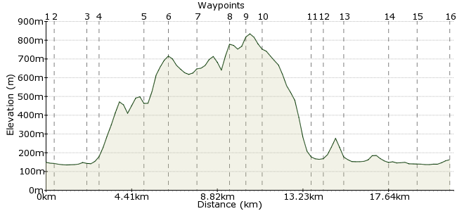
Ascent
786m (2578ft)
Descent
773m (2536ft)
Max. Elevation
840m (2755ft)
Altitude Gain & Loss
1559m (5114ft)
Start & End
Threlkeld
Distance
21.00km
(13.05mi)
(13.05mi)
Duration
~8:15h
Difficulty
Strenuous
Ordnance Survey Map
This walk from Threlkeld covers the peaks that lie just north of Helvellyn, Clough Head, Watson's Dodd and Stybarrow Dodd. The return follows the valley of St John's in the Vale back to Threlkeld. A great walk in a quieter part of the Lakes.
Walk Functions
Share
Nearby Walks
Blencathra - the Saddleback
A leisurely, circular walk (mountain (above 600m)) starting in Cumbria, England, about 6.60km (4.10 mi) long, duration: ~3:45h.The old line to Threlkeld
A moderate, circular walk (riverside) starting in Cumbria, England, about 11.70km (7.27 mi) long, duration: ~4:15h.Make the most of Skiddaw
A moderate, circular walk (mountain (above 600m)) starting in Cumbria, England, about 16.50km (10.25 mi) long, duration: ~7:15h.Walk Map
- $walk->POI array(0)
Waypoints
OS Grid NY317251
Take the bus to Threlkeld.
OS Grid NY314246
Head southwest out of the town, crossing the main Keswick-Penrith road, to reach Threlkeld Bridge.
About 0.53 km (~0.33 miles) from 
OS Grid NY312231
A footpath leads south towards Wanthwaite.
About 1.55 km (~0.96 miles) from 
OS Grid NY319231
Follow the road through the village and take the track past the quarries to Threlkeld Knotts.
About 0.68 km (~0.42 miles) from 
OS Grid NY341233
The Old Coach Road circuits around the northern edge of Clough Head until you reach a stile, just before an old rusty shelter. The path up to Clough Head starts here.
About 2.28 km (~1.42 miles) from 
OS Grid NY334225
The summit is one of the best places to admire Blencathra.
About 1.16 km (~0.72 miles) from 
OS Grid NY330211
Follow the ridge line south to Calfhow Pike.
About 1.44 km (~0.89 miles) from 
OS Grid NY336195
Continue to Watson's Dodd - beautiful views along St John's in the Vale.
About 1.69 km (~1.05 miles) from 
OS Grid NY343189
The highest point of the route at 843m.
About 0.88 km (~0.55 miles) from 
OS Grid NY341181
At Stick's Pass, head down to the valley via the bridleway.
About 0.74 km (~0.46 miles) from 
OS Grid NY318189
Drop into Legburthwaite. Follow the minor road north, not the main Ambleside-Keswick road, which can be busy. For a shorter walk, you can pick up the 555 bus to Keswick from here, then connect to Threlkeld.
About 2.42 km (~1.5 miles) from 
OS Grid NY316194
At Sawmill, take the road to the left. This leads to the Keswick-Ambleside road; follow this for a few metres before you reach the footpath that follows the river.
About 0.59 km (~0.37 miles) from 
OS Grid NY317205
The perfect combo - a high walk to start, then back along the valley.
About 1.09 km (~0.68 miles) from 
OS Grid NY310226
Once you return to Wanthwaite, you just need to retrace your steps to Threlkeld.
About 2.21 km (~1.37 miles) from 
OS Grid NY311240
Return along the same footpath to Threlkeld.
About 1.41 km (~0.88 miles) from 
 Threlkeld again
OS Grid NY320254
Back in time for a pint in the village.
About 1.67 km (~1.04 miles) from 

2 comments... join the discussion!
Timwoods
Try down in Deepdale, just below waypoint 8
Ted leighton
Any good places to do a wild camp