Bourne Bridge to Pinmill
A moderate walk (riverside) in Suffolk, England, about 13.90km (8.64 mi) long with an estimated walking time of about 4:00h. It is suitable for families with children, but unsuitable for prams & pushchairs, wheelchairs.
Elevation Profile
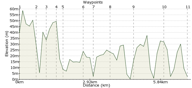
Ascent
68m (223ft)
Descent
71m (232ft)
Max. Elevation
60m (196ft)
Altitude Gain & Loss
139m (455ft)
Start & End
Bourne Bridge, Ipswich
Distance
13.90km
(8.64mi)
(8.64mi)
Duration
~4:00h
Difficulty
Moderate
Ordnance Survey Map
A riverside walk with splendid views of the River Orwell in Suffolk. See the folly (tower) and have lunch right on the water's edge at the beauty stop of Pin Mill.
Â
Walk Functions
Share
Nearby Walks
Martlesham Creek and the River Deben
A leisurely, circular walk (riverside) starting in Suffolk, England, about 5.10km (3.17 mi) long, duration: ~1:30h.Trimley Marshes and Felixstowe port
A leisurely, circular walk (riverside) starting in Suffolk, England, about 9.10km (5.65 mi) long, duration: ~2:45h.Dedham Vale and the Stour Valley
A leisurely, linear walk (riverside) starting in Suffolk, England, about 6.40km (3.98 mi) long, duration: ~1:45h.Walk Map
- $walk->POI array(0)
Waypoints
OS Grid TM160420
Walk South and follow the Stour and Orwell Walk footpath under the Orwell Bridge.
OS Grid TM169410
You will have to walk on the B1080 for about half a mile.
About 1.32 km (~0.82 miles) from 
OS Grid TM173403
Turn right onto footpath going up hill through freston wood to church.
About 0.84 km (~0.52 miles) from 
OS Grid TM170395
Turn left at the church, along lane and cross B1080. Take a little diversion to look at the tower (folly) and beautiful river views. Retrace your steps to rejoin the Stour and Orwell Walk footpath.
About 0.77 km (~0.48 miles) from 
OS Grid TM176394
Stay on footpath towards Woolverstone church.
About 0.56 km (~0.35 miles) from 
OS Grid TM190385
Follow footpath to the river, with a large private school on your right.
About 1.59 km (~0.99 miles) from 
OS Grid TM196389
Continue on path to Pin Mill.
About 0.77 km (~0.48 miles) from 
OS Grid TM205378
Pub and picnic area. Retrace your steps, but instead of following the river, turn left to walk through Woolverstone park.
About 1.38 km (~0.86 miles) from 
OS Grid TM189384
School will now be on your right. You will rejoin the Stour and Orwell Walk. Back through Freston Wood - about 2 miles.
About 1.72 km (~1.07 miles) from 
OS Grid TM173402
Either continue on the riverside path or take path on your left through fields under the Orwell Bridge and return to Bourne Bridge.
About 2.41 km (~1.5 miles) from 
 Ipswich
OS Grid TM161418
Finish back at Bourne Bridge for buses into Ipswich.
About 2.02 km (~1.26 miles) from 

1 comment... join the discussion!
Timwoods
We can do this one next time I am in Suffolk!