Walking in the White Peak
A moderate walk (countryside) in national park Peak District in Derbyshire, England, about 13.70km (8.51 mi) long with an estimated walking time of about 4:30h. It is suitable for families with children, but unsuitable for prams & pushchairs, wheelchairs.
Elevation Profile
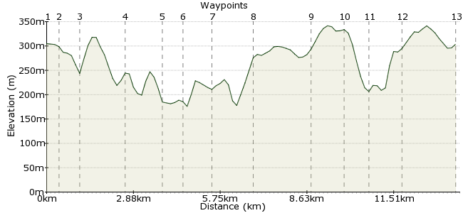
Ascent
255m (836ft)
Descent
256m (839ft)
Max. Elevation
350m (1148ft)
Altitude Gain & Loss
511m (1675ft)
Start & End
Litton, Buxton, Derbyshire, England
Distance
13.70km
(8.51mi)
(8.51mi)
Duration
~4:30h
Difficulty
Moderate
Ordnance Survey Map
Walk Functions
Share
Nearby Walks
A day of dales
A moderate, circular walk (countryside) starting in Derbyshire, England, about 17.20km (10.69 mi) long, duration: ~5:30h.Across the Divide - Hope to Edale
A leisurely, linear walk (low hills and fells (below 600m)) starting in Derbyshire, England, about 8.60km (5.34 mi) long, duration: ~3:15h.The Hope Valley Skyline Walk southern half
A moderate, linear walk (low hills and fells (below 600m)) starting in Derbyshire, England, about 16.70km (10.38 mi) long, duration: ~6:15h.Walk Map
- $walk->POI array(0)
Waypoints
OS Grid SK165751
Take the bus to Litton. Good connections from Buxton, Sheffield and Chesterfield.
OS Grid SK168747
A path leads from Litton into Tansley Dale.
About 0.50 km (~0.31 miles) from 
OS Grid SK175745
Follow the path round as it curves into the wooded Cressbrook Dale.
About 0.69 km (~0.43 miles) from 
OS Grid SK171731
The path splits, so you can take a high path, or the one along the foot of the dale. Either way, you end up in Cressbrook.
About 1.44 km (~0.89 miles) from 
OS Grid SK177721
A short section of road walking to Upperdale.
About 1.14 km (~0.71 miles) from 
OS Grid SK181716
Cross the bridge on the river, and bear left, following the path to Monsal Head.
About 0.70 km (~0.43 miles) from 
OS Grid SK190717
Just across the river is a great little pub, the Packhorse Inn: www.packhorselongstone.co.uk
About 0.83 km (~0.52 miles) from 
OS Grid SK176717
Retrace your steps and climb on to Rutwell Hill. A bit of advice for the local wildlife?
About 1.35 km (~0.84 miles) from 
OS Grid SK158715
A track leads across High Field's southern edge, with views into Monsal Dale. At Brushfield, head along the track above High Dale.
About 1.81 km (~1.12 miles) from 
OS Grid SK153725
Take the footpath heading northeast to Litton Mill.
About 1.09 km (~0.68 miles) from 
OS Grid SK160730
Cross the River Wye once more to reach Miller's Dale. Then take the permitted footpath to meet the road to Cressbrook.
About 0.84 km (~0.52 miles) from 
OS Grid SK170731
Just as you reach the village, a path heads north. Follow this back to Litton, with more views into Cressbrook Dale.
About 0.99 km (~0.62 miles) from 
 Litton once more
OS Grid SK164749
Finish up in Litton and a pint in the Red Lion: theredlionlitton.co.uk
About 1.82 km (~1.13 miles) from 
