Little Assynt to Lochinver
A moderate walk (low hills and fells (below 600m)) starting and finishing in Highlands, Scotland, about 11.90km (7.39 mi) long with an estimated walking time of about 4:00h. It is unsuitable for families with children, prams & pushchairs, wheelchairs.
Elevation Profile
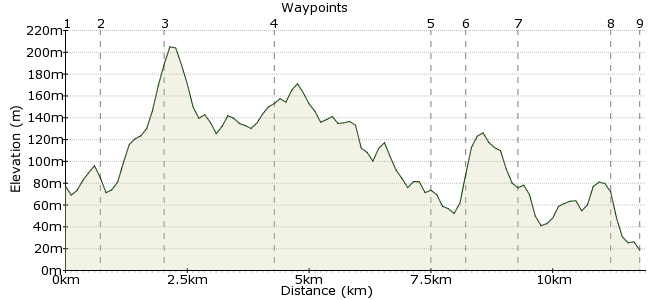
Ascent
194m (636ft)
Descent
267m (875ft)
Max. Elevation
210m (688ft)
Altitude Gain & Loss
461m (1511ft)
Start
A837 at Little Assynt
End
Lochinver, Lairg, Sutherland, Scotland
Distance
11.90km
(7.39mi)
(7.39mi)
Duration
~4:00h
Difficulty
Moderate
Ordnance Survey Map

Walk Functions
Share
Nearby Walks
Achmelvich Beach
A moderate, circular walk (coast) starting in Highlands, Scotland, about 12.90km (8.02 mi) long, duration: ~4:00h.Lochinver to Elphin
A strenuous, linear walk (low hills and fells (below 600m)) starting in Highlands, Scotland, about 21.00km (13.05 mi) long, duration: ~6:45h.Faraid Head, Sutherland
A moderate, circular walk (coast) starting in Highlands, Scotland, about 10.30km (6.40 mi) long, duration: ~3:15h.Walk Map
- $walk->POI array(0)
Waypoints
OS Grid NC156249
After being dropped off by the bus take the path heading south and cross the river
OS Grid NC150244
Cross the Allt an Tiaghaich on stepping stones and head southwest towards a dip on the skyline to the east of Cnoc an Leothaid.
About 0.75 km (~0.47 miles) from 
OS Grid NC148232
From the top of the bealach Suilven appears side on ahead. There is a faint path but if it disappears head towards the southern outflow of Loch an Leothaid then generally south between Loch Crom and Loch Bad an t-Sluic.
About 1.22 km (~0.76 miles) from 
OS Grid NC148211
The path brings you to Suileag bothy and from there turn right following a clear track towards Lochinver. This track is the most popular route to the ascent of Suilven so you are much more likely to encounter other walkers.
About 2.15 km (~1.34 miles) from 
OS Grid NC117220
The track continues through Glencanisp Lodge and could take you straight to Lochinver. But it is far preferable to turn right at the entrance to the grounds of the lodge and find a track heading north.A you climb the view behind opens out again and from the crest turning around you should see the tops of Canisp, Cul Mor and Stac Pollaidh as well as Suilven.
About 3.25 km (~2.02 miles) from 
OS Grid NC120226
Turn left at a gate in the deer fence and descend down a delightful shallow valley towards the river Inver.
About 0.66 km (~0.41 miles) from 
OS Grid NC115234
Reach the river Inver with beautiful views of Quinaig to the northeast. Follow the river downstream through woodland to reach the main road at a bridge.
About 0.90 km (~0.56 miles) from 
OS Grid NC096230
Turn left at the A837 and follow it into the centre of Lochinver. If you're in time then you have to try a pie at the Lochinver Larder pie shop. Buses out of Lochinver leave from near the church.
About 1.90 km (~1.18 miles) from 
 Lochinver
OS Grid NC093226
The walk ends by the church at Lochinver where buses to and from Ullapool arrive and depart.
About 0.54 km (~0.34 miles) from 
