Llanrwst and Trefriw
A leisurely walk (countryside) in national park Snowdonia in Clwyd, Wales, about 8.00km (4.97 mi) long with an estimated walking time of about 2:30h. It is unsuitable for families with children, prams & pushchairs, wheelchairs.
Elevation Profile
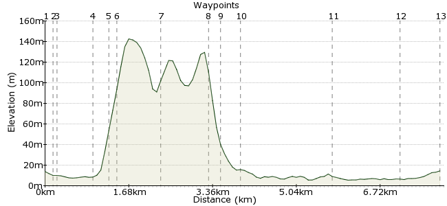
Ascent
136m (446ft)
Descent
136m (446ft)
Max. Elevation
150m (492ft)
Altitude Gain & Loss
272m (892ft)
Start & End
Llanrwst
Distance
8.00km
(4.97mi)
(4.97mi)
Duration
~2:30h
Difficulty
Leisurely
Ordnance Survey Map
 1Created by driver 16 on 28 Jul 2012
Similar to, but slightly different from, Pathfinder Guides Book 32, Walk No. 19. The first and last parts of the walk are across attractive meadows bordering the River Conway, through some woodland on the eastern slopes of Gwydyr Forest with fine views over the Conway Valley. But, having had experience of steep climbs up and down above Trefriw, I gave that part a miss and used the B5106 road, with care, on right side of road. It's single file if more than one person, and not recommended for children (mature teenagers perhaps).
Walk Functions
Share
Nearby Walks
East Llanrwst
A moderate, circular walk (countryside) starting in Clwyd, Wales, about 10.70km (6.65 mi) long, duration: ~3:30h.Lake Crafnant
A moderate, circular walk (mountain (above 600m)) starting in Clwyd, Wales, about 10.10km (6.28 mi) long, duration: ~3:30h.Trefriw to Llanrwst via Llyn Geirionydd
A moderate, circular walk (countryside) starting in Clwyd, Wales, about 10.30km (6.40 mi) long, duration: ~3:30h.Walk Map
- $walk->POI array(0)
Waypoints
OS Grid SH799616
Look for Ysgol Bro Gwdir at the corner of Conway Terrace. Cross over the road and continue to the T-junction, waypoint 2.
OS Grid SH798615
Look right to see a bridge built in 1636. Cross the bridge and on the left look for the footpath sign at the start of a tarmac path opposite Tu-hwnt-i'r-bont, a 15th century courthouse. This is now owned by the National Trust and used as gift shop and tearoom.
About 0.14 km (~0.09 miles) from 
OS Grid SH798614
Continue beside the river, with grand views upstream, through a metal kissing gate and keep on ahead to a stile.
About 0.08 km (~0.05 miles) from 
OS Grid SH798607
Climb over the stile and turn right along the right edge of a field to a ladder stile.
About 0.69 km (~0.43 miles) from 
OS Grid SH797605
Climb over, and turn right along the road until you see a sign for Gwydyr Uchaf Chapel.
About 0.23 km (~0.14 miles) from 
OS Grid SH796606
Cross the road and turn sharply left along a tarred forestry road. Where this road bends sharply right, go straight ahead along a steep uphill path through the trees of Gwydyr Forest and on to waypoint 7.
About 0.17 km (~0.11 miles) from 
OS Grid SH788609
Turn sharply right along a tarred forest track. Where this track forks, take the right-hand lower track. Nice views over Llanrwst to the right and Trefriw ahead. Follow to pass through a parking area and on to waypoint 8.
About 0.85 km (~0.53 miles) from 
OS Grid SH783616
Look over the road to see a sign pointing right for Llanrwst, left for Llyn Gerionedd and straight ahead for Llanrhychwyn. Take the path straight ahead; cross a stream to find another ladder stile on the right.
About 0.85 km (~0.53 miles) from 
OS Grid SH786616
Climb over the stile and follow a graded path down to Grey Mare's waterfall, a spectacular, graceful twin falls. Turn left at the falls to follow a path coming out on the B5106.
About 0.28 km (~0.17 miles) from 
OS Grid SH788614
Turn left on to the B5106, cross to the right side of the road. Be careful - walk in single file if more than one person. Follow the road into Trefriw.
About 0.33 km (~0.21 miles) from 
OS Grid SH781630
At the Woollen Mill (also the start of walk 'Llyn Crafnant' another of my walks on this site) turn right. Look for the notice board with 'Trefriw Trails'. The route is straightforward now, down to a pedestrian suspension bridge.
About 1.78 km (~1.11 miles) from 
OS Grid SH792622
Cross the bridge and after only a few yards you will see a railway station (although trains are few and far between). Carry on to the main road, turn right, and the bus stop is on the right. Or, carry on into town and use the bus stop from the start of the walk, where there is a choice of two services.
About 1.37 km (~0.85 miles) from 
 End of the walk
OS Grid SH798617
Hope you made it and enjoyed it.
About 0.74 km (~0.46 miles) from 
