Hawarden Park and farm shop
A moderate walk (countryside) in Flintshire, Wales, about 10.00km (6.21 mi) long with an estimated walking time of about 3:00h. It is suitable for families with children, but unsuitable for prams & pushchairs, wheelchairs.
Elevation Profile
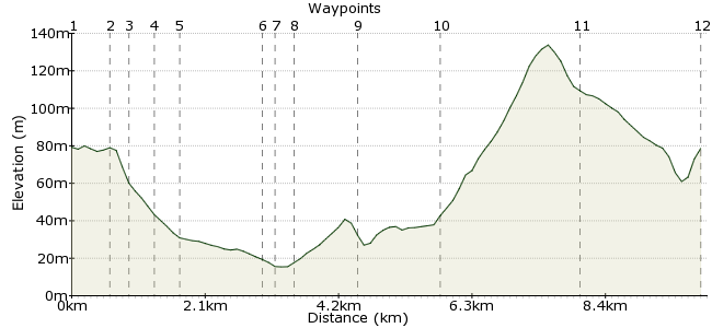
Ascent
97m (318ft)
Descent
98m (321ft)
Max. Elevation
140m (459ft)
Altitude Gain & Loss
195m (639ft)
Start & End
Hawarden
Distance
10.00km
(6.21mi)
(6.21mi)
Duration
~3:00h
Difficulty
Moderate
Ordnance Survey Map
 1Created by driver 16 on 02 Aug 2012
This is an easy, no hills, attractive walk close to the England-Wales border. There are fine views over Deeside and the Cheshire plain, and you may see the ruins of the Old Castle, and its successer the New Castle. This was once the home of the great Victorian statesman William Gladstone.Â
Walk Functions
Share
Nearby Walks
Ewloe Castle
A leisurely, circular walk (woodland) starting in Flintshire, Wales, about 3.60km (2.24 mi) long, duration: ~1:15h.Mold walk - Daniel Owen
A leisurely, circular walk (city/town) starting in Flintshire, Wales, about 3.20km (1.99 mi) long, duration: ~0:45h.The city walls of Chester
A leisurely, circular walk (city/town) starting in Cheshire, England, about 3.40km (2.11 mi) long, duration: ~0:45h.Walk Map
- $walk->POI array(0)
Waypoints
OS Grid SJ310658
Walk through the car park to the main road, Glynne Way, and turn right. Cross the road to see the Gladstone Monument. Just beyond is a large stone drinking fountain (not in use) on the right. Cross over to Tree Lane.
OS Grid SJ316656
Turn left and cross over. Between a school and cemetery is a public footpath; turn right on this to waypoint 3.
About 0.61 km (~0.38 miles) from 
OS Grid SJ318659
From waypoint 2, ignore the wooden footbridge and keep going until the path enters a field. Keep the hedge on your right, and at the bottom corner turn left. Again, keep the hedge on your right as you walk to the next corner where you will see a stile.
About 0.28 km (~0.17 miles) from 
OS Grid SJ317662
Here there are two well-defined paths on the right. Take the lower one and keep straight on this path to a metal kissing gate This leads into a cul-de-sac. Look for the footpath sign on the other side; cross over to this and pass through the metal kissing gate.
About 0.37 km (~0.23 miles) from 
OS Grid SJ320664
From here, keeping the hedges on your left, cross two large fields to waypoint 6.
About 0.32 km (~0.2 miles) from 
OS Grid SJ330657
Turn left along a tarmac lane. Continue for nearly half a mile, until you see a footpath sign on the right.
About 1.25 km (~0.78 miles) from 
OS Grid SJ332656
Cross the field and climb over a stile on other side to waypoint 8.
About 0.17 km (~0.11 miles) from 
OS Grid SJ334655
Keep the hedge on your right, and continue to a stile into a wood of young conifers. It's a short walk to another stile; climb over, and over a drainage ditch, then turn left to follow the ditch. You will pass an Airbus factory; look for two oak trees and go diagonally to the right of the trees. Look for the last visible wooden pylon ahead and aim for this.
About 0.23 km (~0.14 miles) from 
OS Grid SJ329647
Cross two more fields to waypoint 10.
About 0.94 km (~0.58 miles) from 
OS Grid SJ327634
Turn right and stay on this road through Old Warren. Ignore the footpath sign on the right to Cherry Orchard Farm. Stay on the road to waypoint 11.
About 1.26 km (~0.78 miles) from 
OS Grid SJ307641
Turn right; when you reach Rake Lane, look for a sign for a farm shop. The entrance is on the left. It's ideal for refreshments; if closed, it's only 15 minutes further into Hawarden.
About 2.17 km (~1.35 miles) from 
 End of the walk
OS Grid SJ314657
You have a choice of either taking the train or the bus home.
About 1.82 km (~1.13 miles) from 
