Betws-y-Coed and Llyn Elsi
A leisurely walk (woodland) in national park Snowdonia in Gwynedd, Wales, about 3.90km (2.42 mi) long with an estimated walking time of about 1:45h. It is suitable for families with children, but unsuitable for prams & pushchairs, wheelchairs.
Elevation Profile
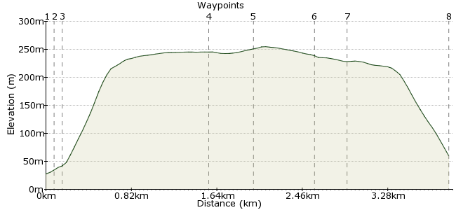
Ascent
224m (734ft)
Descent
192m (629ft)
Max. Elevation
260m (853ft)
Altitude Gain & Loss
416m (1363ft)
Start & End
Betws-y- Coed
Distance
3.90km
(2.42mi)
(2.42mi)
Duration
~1:45h
Difficulty
Leisurely
Ordnance Survey Map
 1Created by driver 16 on 12 Aug 2012
A delightful forest walk, great for a boiling summer's day (the trees shield you from the sun, both on the ascent and descent). This walk has well-maintained paved paths (thin tarmac, gravel and stones), it is clear of heavy undergrowth, and plenty of wayposts. The board at the start suggests two hours duration, but I would say this is for regular walkers; others should allow slightly more than 3 hours.
Walk Functions
Share
Nearby Walks
Four bridges and Swallow Falls nr Betws-Y-Coed
A moderate, circular walk (riverside) starting in Gwynedd, Wales, about 9.60km (5.97 mi) long, duration: ~3:00h.Along the Afon Llugwy
A leisurely, linear walk (riverside) starting in Clwyd, Wales, about 8.10km (5.03 mi) long, duration: ~3:00h.The old slate mines - exploring Snowdonia's history
A leisurely, linear walk (woodland) starting in Clwyd, Wales, about 7.70km (4.78 mi) long, duration: ~3:00h.Walk Map
- $walk->POI array(0)
Waypoints
OS Grid SH794564
Head out to the main road. At the junction, cross at the pelican crossing and turn right to the church (waypoint 2).
OS Grid SH793564
Turn left uphill and bear right around the back of the church to find a signboard on the left. This is the start of the signposted walk.
About 0.08 km (~0.05 miles) from 
OS Grid SH793563
From the signboard, head up a broad forestry road following white arrows on wayposts. This road is quite steep. Ignore the first path on the left, and continue to the Y junction. Take the road to the right. The lower wood is comprised of oak and sycamore; pass this to a higher wood of pine trees. The sound of running streams accompany this bit of the walk. Ignore the forestry road on the right and keep following white arrows on wayposts to waypoint 4.
About 0.09 km (~0.06 miles) from 
OS Grid SH785553
Look for two standing stones just after a waypost; turn right through these onto a gravel path along the side of a lake, with distant views of Moel Siabod, Snowdon and the Carneddau range ahead, and the Clywdian range behind. Continue to find a memorial commemorating the opening of Betws-y-Coed waterworks.
About 1.36 km (~0.85 miles) from 
OS Grid SH784556
Benches here for a breather / picnic, to continue there are There are three wayposts marked with yellow arrows; take the middle one just behind the memorial. It's a narrow, but well maintained gravel path through scrub and over a few boggy patches to a crossroads with a forestry road. Cross straight ahead and continue to the next crossroad (waypoint 6).
About 0.33 km (~0.21 miles) from 
OS Grid SH789559
At the second crossroads, turn right and go slightly uphill. Watch out for a stony path on the right, which crosses and continues on the left.
About 0.56 km (~0.35 miles) from 
OS Grid SH789556
Turn left on to the stony path. This is quite steep in some parts. Next, take a rocky path zigzagging down through the woodlands, again accompanied by the sounds of a stream in the background. Cross the wooden bridge over the stream; you should now recognise the path that you climbed earlier, so, turn left and follow it back to where you started.
About 0.24 km (~0.15 miles) from 
 Back in Betws-y-Coed
OS Grid SH792565
Hope you enjoy it, I'm very lucky to live where I do and still be physically able to take advantage of this area!
About 0.92 km (~0.57 miles) from 
