Amlwch to Llaneilian
A leisurely walk (coast) in Isle of Anglesey, Wales, about 8.20km (5.10 mi) long with an estimated walking time of about 2:30h. It is suitable for families with children, but unsuitable for prams & pushchairs, wheelchairs.
Elevation Profile
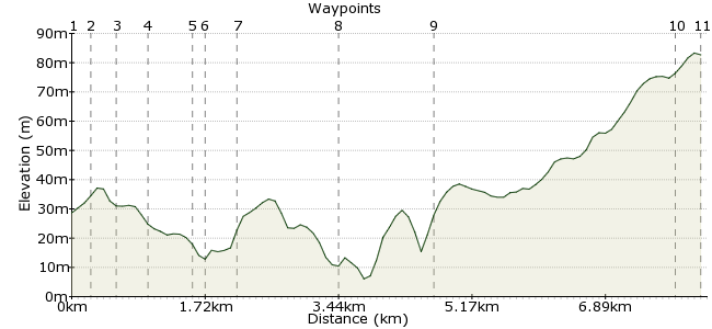
Ascent
82m (269ft)
Descent
28m (91ft)
Max. Elevation
90m (295ft)
Altitude Gain & Loss
110m (360ft)
Start & End
Amlwch
Distance
8.20km
(5.1mi)
(5.1mi)
Duration
~2:30h
Difficulty
Leisurely
Ordnance Survey Map
 1Created by driver 16 on 21 Aug 2012
A walk along part of the Anglesey Coastal Path, visiting Amlwch Port, a narrow natural harbour enlarged about 200 years ago to accommodate the vessels exporting copper from the mines on Parys Mountain. Some of the excavated rock was used to build the pier and to face the dock walls. These were built with vertically placed stones, which is unusual in Anglesey. The method may have been introduced to Amlwch by Cornishmen working in the mines.
Continue along the Coastal Path through yellow and purple gorse, many wild flowers and, believe it or not, blackberry bushes in places, through fields, coves and along cliff tops.
This one comes from 'Circular Walks on Anglesey' by Dorothy Hamilton, publishers Gwasg Carreg Gwalch, Llanrwst.
There is a shorter walk, the Parys Mountain Copper Trail, featured in 'All Terrain Pushchair Walks, Anglesey and Lleyn Peninsular' by Zoe Sayer and Rebbeca Terry, publishers Sigma Press, Wimslow, Cheshire. Â Â
Walk Functions
Share
Nearby Walks
Mynydd Bodafon
A leisurely, linear walk (low hills and fells (below 600m)) starting in Isle of Anglesey, Wales, about 8.90km (5.53 mi) long, duration: ~2:45h.Moelfre
A leisurely, circular walk (coast) starting in Isle of Anglesey, Wales, about 6.10km (3.79 mi) long, duration: ~1:45h.Llangefni - the Dingle Llyn Cefni & Oriel Ynys Mon
A leisurely, circular walk (countryside) starting in Isle of Anglesey, Wales, about 6.50km (4.04 mi) long, duration: ~2:00h.Walk Map
- $walk->POI array(0)
Waypoints
OS Grid SH441928
From the bus stop, go back to the main road. Turn right at the next major junction, the turn right and cross the road to find a faded footpath sign.
OS Grid SH441930
Follow a twisting, undulating path to a three-pronged signpost.
About 0.24 km (~0.15 miles) from 
OS Grid SH440932
Turn right and follow the path to meet a tarmac road. You should see Amlwch Sports and Social Club. Turn right onto the road, then cross to see a stream on your left. This is discoloured by copper salts in the water.
About 0.24 km (~0.15 miles) from 
OS Grid SH444933
Turn left and follow the path along the fence by a children's play area (you could go up to the old windmill, but, you still have to come back to this point). Turn right at the end of the fence, along the back of the play area into a field. Cross the field and exit to waypoint 5.
About 0.39 km (~0.24 miles) from 
OS Grid SH449935
Descend a footpath to reach the end of the harbour. Turn left at the old bouy on the path into the main harbour.
About 0.55 km (~0.34 miles) from 
OS Grid SH450934
The Copper Kingdom Exhibition is located here. I really wanted to visit, but, on this day (Monday) it was closed, with no indication of opening times (check if you want to visit, www.copperkingdom.co.uk). Head right, up past the Sail building to the car park.
About 0.20 km (~0.12 miles) from 
OS Grid SH453935
Back on the Coastal Path, which is well signed with plenty of wayposts. Head through the yellow and purple gorse. There are plenty of wild flowers and, believe it or not, blackberry bushes. Continue on through the fields and over the clifftops to Llaneilian.
About 0.33 km (~0.21 miles) from 
OS Grid SH465933
At the bridge over the stream, try to find remains of a square walled enclosure under a large rock. This is the site of Ffynon (Well) of St. Eilian, said to have landed at Porth yr Ychen in the 6th century.
About 1.21 km (~0.75 miles) from 
OS Grid SH475930
This is a hidden little gem (see video) that caters for all types of water sport. Turn right uphill along a tarmac road to the A5025.
About 1.12 km (~0.7 miles) from 
OS Grid SH449914
Turn left; the bus stop in Cerrig Man is about 1/2 mile away.
About 3.04 km (~1.89 miles) from 
 End of walk
OS Grid SH452912
Hope you enjoyed it and learned about the history of the area.
About 0.35 km (~0.22 miles) from 
